The Project Gutenberg eBook of Everglades Wildguide
Title: Everglades Wildguide
Author: Jean Craighead George
Illustrator: Betty Fraser
Release date: June 24, 2017 [eBook #54970]
Most recently updated: October 23, 2024
Language: English
Credits: Produced by Stephen Hutcheson, MFR and the Online
Distributed Proofreading Team at http://www.pgdp.net
Handbook 143
Everglades Wildguide
by Jean Craighead George
Illustrations by Betty Fraser
The Natural History of Everglades National Park, Florida
Produced by the
Division of Publications
National Park Service
U.S. Department of the Interior
Washington, D.C. 1988
About This Book
Here is the story of the plants and animals of the Everglades, this country’s subtropical kingdom. Plants and animals found nowhere else in the 50 states are found here in abundance, though in an increasingly perilous state. In this handbook, first published in 1972, author and researcher Jean Craighead George brings to the telling of this story long years of study and understanding. Checklists and glossaries at the back buttress her account of the natural history of this national park.
National Park Handbooks, compact introductions to the great natural and historic places administered by the National Park Service, are published to support the National Park Service’s management programs at the parks and to promote understanding and enjoyment of the parks. Each is intended to be informative reading and a useful guide before, during, and after a park visit. More than 100 titles are in print. This is Handbook 143. You may purchase the handbooks through the mail by writing to Superintendent of Documents, U.S. Government Printing Office, Washington, DC 20402.
- Library of Congress card number: 73-600077
- ISBN 0-912627-29-8
★GPO: 1987—181-917/60504
- Preface vii
- America’s Subtropical Wonderland 1
- Pine Rockland 7
- Tree-Island Glades 12
- Mangrove Swamp 16
- Florida Bay and the Coastal Prairie 21
- Big Cypress Swamp 26
- Plant-and-Animal Communities 29
- Tropical Hardwood Hammock 30
- Cypress Head 35
- Bayhead 38
- Willow Head 40
- Web of Life in the Marsh 42
- Alligator Hole in the Glades 45
- Discovering Everglades Plants and Animals 49
- Air Plants 52
- Mammals 59
- Birds 64
- Reptiles and Amphibians 70
- Fishes 72
- Animals without Backbones 75
- Indians of the Everglades 77
- Appendix 80
- Glossary 81
- For Reading and Reference 84
- Rare and Endangered Animals 86
- Checklist of Mammals 87
- Checklist of Birds 88
- Checklist of Reptiles and Amphibians 96
- Checklist of Trees 98
EVERGLADES NATIONAL PARK
High-resolution Map
PREFACE
The shimmering waters of the everglades creep silently down the tip of Florida under warm subtropical skies. In a vast, shallow sheet this lazy river idles through tall grasses and shadowy forests, easing over alligator holes and under bird rookeries, finally mingling with the salty waters of Florida Bay and the Gulf of Mexico in the mangrove swamps. From source to sea, all across the shallow breadth of this watery landscape, life abounds.
Everglades National Park is to most Americans an Eden where birds, mammals, reptiles, and orchids find sanctuary. Sunshine sparkles on sloughs teeming with fish, and on marshes where wildflowers bloom the year around; it shines on tree islands where birds roost and deer bed down. In this semitropical garden of plant-and-animal communities, every breeze-touched glade, every cluster of trees is a separate world in which are tucked yet smaller worlds of such complexity that even ecologists have not learned all their intricate relationships.
This book has been written to help you see how the many pieces of this ecological puzzle fit together to form a complex, ever-changing, closely woven web of plants, animals, rock, soil, sun, water, and air.
AMERICA’S SUBTROPICAL WONDERLAND
Everglades may not be our largest national park (that honor belongs to Wrangell-St. Elias in Alaska), but it is certainly the wettest. During and after the rainy season, when not only the mangrove swamp but also the sawgrass prairie is under water, most of the park abounds in fish and other water life, and even the white-tailed deer leads a semi-aquatic existence.
Despite the fact that it is low, flat, and largely under water, Everglades is a park of many environments: shallow, key-dotted Florida Bay; the coastal prairie; the vast mangrove forest and its mysterious waterways; cypress swamps; the true everglades—an extensive freshwater marsh dotted with tree islands and occasional ponds; and the driest zone, the pine-and-hammock rockland.
The watery expanse we call “everglades,” from which the park gets its name, lies only partly within the park boundaries. Originally this river flowed, unobstructed though very slowly, southward from Lake Okeechobee more than 100 miles to Florida Bay. It is hardly recognizable as a river, for it is 50 miles wide and averages only about 6 inches deep, and it creeps rather than flows. Its source, the area around Lake Okeechobee, is only about 15 feet above sea level, and the riverbed slopes southward only 2 or 3 inches to the mile.
As you can see by the maps on pages 2 and 3, the works of man have greatly altered the drainage patterns and the natural values of south Florida, and you can imagine how this has affected the supply of water—the park’s lifeblood.
The park’s array of plants and animals is a blend of tropical species, most of which made their way across the water from the Caribbean islands, and species from the Temperate Zone, which embraces all of Florida. All of these inhabitants exist here through adaptation to the region’s peculiar cycles of flood, drought, and fire and by virtue of subtle variations in temperature, altitude, and soil.
HISTORIC DRAINAGE PATTERNS OF SOUTH FLORIDA
DRAINAGE PATTERNS OF SOUTH FLORIDA TODAY
PLANT COMMUNITIES OF EVERGLADES NATIONAL PARK
The horizontal distance represented on this diagram, from the Pineland to Florida Bay, is 15 miles. With a greatly exaggerated vertical scale, the difference between the greatest elevation of the pine ridge and the bottom of the Florida Bay marl bed is only 14 feet.
- FLORIDA BAY (SALT WATER)
- MUD BANK
- KEY
- COASTAL PRAIRIE
- MANGROVE SWAMP (BRACKISH)
- BUTTONWOOD LEVEE
- TREE-ISLAND GLADES (FRESH WATER)
- BAYHEAD
- CYPRESS HEAD
- WILLOW HEAD
- HARDWOOD HAMMOCK
- PINE AND HAMMOCK RIDGE
Underlying the entire park is porous limestone (see glossary), which was deposited ages ago in warm seas that covered the southern part of today’s Florida peninsula. Over this limestone only a thin mantle of marl and peat provides soil for rooting plants.
Some of the park’s ecosystems (see glossary) are extremely complex. For example, a single jungle hammock of a dozen acres may contain, along with giant live oaks and other plants from the Temperate Zone, many kinds of tropical hardwood trees; a profusion of vines, mosses, ferns, orchids, and air plants; and a great variety of vertebrate and invertebrate animals, from tree snails to the white-tailed deer.
Pine Rockland
Entering the park from the northeast, you are on a road traversing the pineland-and-hammock “ridge.” This elevated part of the South Florida limestone bedrock, which at the park entrance is about 6 feet above sea level, is the driest zone in the park. Pine trees, which will grow only on ground that remains above water most of the year, thrive on this rockland.
There is another condition essential to the survival of the pine forest in this region—fire. We usually think of fire as the enemy of forest vegetation; but that is not true here. The pines that grow in this part of Florida have a natural resistance to fire. Their thick, corky bark insulates their trunks from the flames. And strangely enough the fire actually seems to help with pine reproduction; it destroys competing vegetation and exposes the mineral soil seedlings need. If there has been a good cone crop, you will find an abundant growth of pine seedlings after a fire in the pinelands.
What would happen if the pinelands were protected from fire? Examine a pine forest where there have been no recent fires. You will note that there are many small hardwood (broadleaved) trees growing in the shade of the pines. These hardwoods would eventually shade out the light-demanding pine seedlings, and take over as the old pines died off. But under normal conditions, lightning-caused fires sweep at fairly frequent intervals through the pineland. Since the hardwoods have little resistance to fire, they are pruned back.
Before this century, fires burned vast areas. The only barriers were natural waterways—sloughs, lakes and ponds, and estuaries—which retained some water during the rainless season when the rest of the glades and pinelands dried up. Old-timers say that sometimes a fire would travel all the way from Lake Okeechobee to the coastal prairie of Cape Sable (see page 2). In the pine forest, any area bypassed by these fires for a lengthy period developed into a junglelike island of hardwoods. We call such stands “hammocks,” whether they develop in the pine forest or in the open glades. On the limestone ridge, the hammocks support a community of plants and animals strikingly different from the surrounding pine forests.
PINE AND HAMMOCK RIDGE
(elevation: 3 to 7 feet above sea level)
- SAWGRASS GLADES
- PINELAND
- HARDWOOD HAMMOCK
- PINELAND
- 1 SOUTH FLORIDA SLASH PINE
- 2 SAW-PALMETTO
- 3 COONTIE
- 4 SAW-PALMETTO AFTER FIRE
With the opening up of south Florida for farming and industry, man’s works—particularly roads and canals—soon crisscrossed the region, forming barriers to the spread of the fires. Suppression of fire by farmers, lumbermen, and park managers also lessened their effect. Thus the hardwoods, which previously had been held back by fire, tended to replace the pines. And although the park was established to preserve a patch of primitive subtropical America as it was in earlier centuries, the landscape began to change.
Continued protection of the park from fire would in time eliminate the pineland—a plant community that has little chance to survive elsewhere. So, in Everglades National Park, Smokey Bear must take a back seat: park rangers deliberately set fires to help nature maintain the natural scene. Thus, as you drive down the road to Flamingo, do not be shocked to discover park rangers burning the vegetation. The fires are controlled, of course, and the existing hammocks are not destroyed.
When you visit the park take a close look at the pinelands community. Notice, as you walk on the manmade trail through the pine forest, that the ground on either side of you is extremely rough. The limestone bedrock is visible everywhere; what soil there is has accumulated in the pits and potholes that riddle the bedrock. The trees, shrubs, grasses, and other plants are rooted in these pockets of soil.
The limestone looks rather hazardous to walk on—and it is. You must be careful not to break through a thin shell of rock covering a cavity. This pitted, honeycombed condition is due to the fact that the limestone is easily dissolved by acids. Decaying pine needles, palmetto leaves, and other dead plant materials produce weak acids that continually eat away at the rock.
If a fire has passed through the pineland recently, you may notice that while most of the low-growing plants have been killed, some, such as the saw-palmetto, are sending up new green shoots. The thick, stubby stem of the palmetto lies in a pothole, with its roots in the soil that has accumulated there; even in the dry season the pocket in the limestone remains damp, for water is never very far below the surface in this region. When fire kills the top of the plant, the stem and roots survive, and the palmetto, like the pine, remains a part of the plant community.
A number of other plants of the south Florida pinelands have adapted to the conditions of periodic burning. Coontie (a cycad, from the underground stems of which the Indians made flour) and moon vine (a morningglory) are among many you will see surviving pineland fires severe enough to result in the death or stunting of the hardwood seedlings and saplings.
Sometimes we forget that fire—like water, wind, and sunlight—is a natural force that operates with the others to influence the evolution of plants as well as to shape the landscape.
The pineland, like other plant communities, has its own community of animals. Some of its residents, such as the cotton mouse, opossum, and raccoon, are found in other communities of the park, too.
Some of the pineland animals, however—pine warbler, reef gecko, and five-lined skink, for example—are particularly adapted to this environment. These lovers of sunlight are dependent, like the pine forest, on the occasional natural or manmade fires that hold back the hardwood trees.
The pine rockland is quite different from the other plant-and-animal communities you will see as you drive through the park: it is the only ecosystem you can explore on foot in any season. Other parts of the park are largely flooded during the wet season. Elevated boardwalks have been provided in some of these areas to enable you to penetrate them a short distance from the road.
As you will see, fire plays an important role in some of the other Everglades communities, too.
Tree-island Glades
(elevation: 1 to 3 feet above sea level)
- BAYHEAD
- WILLOW HEAD
- SAWGRASS
- PINE
- DWARF CYPRESS FOREST
- ALLIGATOR HOLE
- CYPRESS HEAD
PIG FROG
one-third life size
GREEN TREEFROG
one-third life size
SQUIRREL TREEFROG
color variation
Beyond the pinelands the road, having descended some 2 feet from the park entrance, brings you into the true everglades—the river of grass, or, as the Seminoles call it, Pa-Hay-Okee (grassy waters). To the eye, the glades look like a very flat, grassy prairie broken by scattered clumps of trees. During the dry season (winter) it is in fact a prairie—and sometimes burns fiercely. The dominant everglades plant is sawgrass (actually not a grass but a sedge). The tree islands develop in both high and low spots of the glades terrain. In this unbelievably flat country, small differences in elevation—measured in inches rather than feet—cause major differences in the plantlife: tropical hardwoods on the “mesas,” and swamp trees in the potholes.
A spot in the glades where the limestone base is elevated just 2 feet will be occupied by a small forest of tropical hardwoods and palms—a “hammock” much like those of the pinelands. A low spot—just a few inches below the general level of the limestone base—will remain wet even in the relatively rainless winter when the sawgrass becomes tinder dry. This sloughlike depression will support a stand of baldcypress, called a “cypress head.” Other tree islands, called bayheads and willow heads, develop in many places where soil and peat accumulate.
Step from the sawgrass glades into one of these hammocks or heads; you will find yourself in another world. You cannot know the park until you have investigated these plant-and-animal communities so distinct from the surrounding marsh yet so much a part of it. As you drive through the park, look for the trails provided to give you easy access into the interior of the tree islands.
Also characteristic of the glades are the sloughs—channels where the glades water, generally a thin, seemingly motionless sheet, is deeper and has a noticeable current. The sloughs support a rich plantlife and attract a variety of animals, particularly during the dry season when the water level drops below the shallow glades bottom. Animals that live in the glades when they are under water must migrate or estivate (see glossary) if they are to survive the rainless months. Many migrate to the sloughs, the best known of which is Taylor Slough, where the elevated Anhinga Trail enables you to walk over the water and observe the wildlife.
Fire is an important factor in the ecology of the tree-island glades, just as it is in the pineland. Here, too, artificial barriers such as canals and roads have hindered the spread of natural fires. There is some evidence that tree islands were scattered more thinly over the sawgrass prairie a half-century ago, when a single fire might wipe out scores of them and destroy much of the bed of peat that provided a foothold for them. A bird’s-eye view of the glades region today shows many tree islands that have been established in recent decades. But park rangers are now utilizing controlled fires in the glades as well as in the pineland. This tends to prevent new tree islands from taking hold, and thus helps maintain the natural everglades landscape.
Driving over the glades toward Florida Bay, you come to a sign reading “Rock Reef Pass—Elevation 3 Feet.” The road then traverses the so-called dwarf cypress forest. The forest is an open area of scattered, stunted baldcypress growing where marl (which, unlike peat, does not burn) has accumulated in small potholes dissolved in the limestone. These marl potholes provide a foothold for the dwarf cypresses in an area that is spotted with cypress heads containing much larger trees. Many of the dwarf cypresses are more than 100 years old, while tall cypresses in the heads may be less than 50 years old. These anomalies can be attributed to varying soil depths and water levels and to the effects of fire.
Before you reach the limit of the fresh-water marsh you will come to a side road leading to Mahogany Hammock. (A good foot trail makes it easy to explore this hardwood jungle island.) Just beyond, you will notice the first red mangroves. Small and scattered in this zone, they are a signal that you are approaching a strikingly different plant-and-animal community, the mangrove swamp.
Mangrove Swamp
(elevation: sea level to 1 foot above sea level)
PRAIRIE SEDGES
- BAY
- JAMAICA DOGWOOD
- GUMBO-LIMBO
- MAHOGANY
- PRAIRIE SEDGES
- BUTTONWOOD
- WHITE-MANGROVE
- OSPREY NEST
- BLACK-MANGROVE
- RED-MANGROVE (very dense growth)
- ESTUARY
BONEFISH Comes in with the tide to feed on crabs and mollusks in shallow water
FLORIDA HORN SHELL Lives in shallow water and feeds upon algae and other aquatic plants
’COON OYSTER A small (1½″) oyster that lives attached to the roots of mangroves
The southward-creeping waters of the glades eventually meet and mingle with the salty waters of the tidal estuaries. In this transition zone and along the gulf and Florida Bay coasts a group of trees that are tolerant of salty conditions, called “mangroves,” form a vast, watery wilderness. Impenetrable except by boat, it occupies hundreds of square miles, embracing both the shifting zone of brackish water and the saltier coastal waters.
Several kinds of trees are loosely called “mangroves.” The water-tolerant red mangrove grows well out into the mudflats and is easily recognized by its arching stiltlike roots. Black-mangrove typically grows at levels covered by high tide but exposed at low tide, and it is characterized by the root projections called pneumatophores that stick up out of the mud like so many stalks of asparagus growing in the shade of the tree. White-mangrove has no peculiar root structure and grows, generally, farther from the water, behind the other trees. Sometimes all three are found in mixed stands.
This mangrove wilderness, laced by thousands of miles of estuarine channels (called “rivers” and “creeks”) and broken by numerous bays and sounds, is extremely productive biologically. The brackish zone is particularly valuable as a nursery ground for shrimp. The larvae and young of these marine crustaceans and of other marine animals remain in this relatively protected environment until they are large enough to venture into the open waters beyond the mangroves.
The shrimp represent a multi-million-dollar industry, and the sports-fishing business of the area is said to exceed that by far. Both would suffer if any damage occurred to this ecosystem. The greatest danger is the alteration in the flow of fresh waters from the glades and cypress swamps that occurs when new canals are built and land is drained for cultivation or development. The flow carries with it into the estuaries organic materials from the rich glades ecosystem; these supplement the vast quantities of organic matter derived from the decay of red mangrove leaves. Thus, a reduction in the amount of nutrient-laden fresh water flowing into the mangrove region will affect the welfare of the ecosystem, and indirectly the livelihood or recreation of many persons.
The productive zone of brackish water varies in breadth according to the flow of fresh water. In the wet summer it moves seaward as the flow of fresh water from the glades pushes the tides back. In the drier winter the bay and gulf waters move inland and the brackish zone is quite narrow. The drainage and canal-building operations in south Florida can be extremely disruptive here, since too little, or too much, fresh water flowing into the estuaries can interfere with their productivity.
Natural disasters such as hurricanes can also bring about great changes in the mangrove ecosystem. Yet biologists do not necessarily view the destruction of mangroves by hurricanes as catastrophic. The hurricanes have been occurring as long as the mangroves have grown here and are part of the complex of natural forces making the region what it is.
Fire does not seem to be a problem in the mangrove wilderness. The trees themselves are not especially fire-resistant, but it is not uncommon to see a glades fire burn to the edge of the mangroves and stop when it runs out of fine fuel.
The mangrove wilderness is a mecca for many park visitors. Sportsmen take their motorboats into the bays and rivers to challenge the fighting tarpon. Bird lovers seek the roosts and rookeries of herons and wood storks. Canoeists, the only ones able to explore the secret depths, are drawn by the spell of labyrinthine channels under arching mangrove branches. Here, in a wilderness still thwarting man’s efforts at destruction, one experiences a feeling of utter isolation from the machine world.
But the relentlessly rising sea of the past 10,000 years has belittled drought, fire, hurricane, and frost as it slowly inundated this land 3 inches each hundred years. In compensation, the mangrove forest adds peat and rises with the sea. The sawgrass marshes retreat, and the mangrove ecosystem prevails essentially unchanged.
APPLE MUREX
A carnivorous mollusk that feeds on oysters.
Florida Bay and the Coastal Prairie
When you reach Flamingo, a former fishing village and now a center for visitor services and accommodations, you will be on the shore of Florida Bay. Here is an environment rich in variety of animal life, where porpoises play, the American crocodile makes its last stand, and the great white heron, once feared doomed to extinction, holds its own. The abundance of game fish in the bay has given it a reputation as one of the best sport-fishing grounds on the east coast.
The bay’s approximately 100 keys (low-lying islets) were built up by mangroves and provide foothold for other plants hardy enough to withstand the salty environment and the sometimes violent winds. The keys are also a breeding ground for water birds, ospreys, and bald eagles.
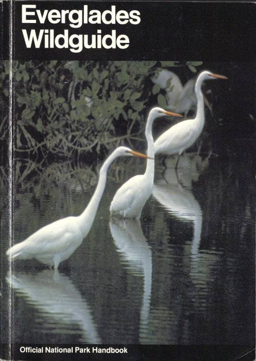
Florida Bay, larger than some of our States, is so shallow that at low tide some of it is out of water; its greatest depth is about 9 feet. The shallows and mudflats attract great numbers of wading birds, which feed upon the abundant life sheltered in the seaweeds—a plant-and-animal community nourished by nutrients carried in the waters flowing from the glades and mangroves.
To the west beyond Flamingo is Cape Sable. This near-island includes the finest of the park’s beaches and much of the coastal prairie ecosystem. A fringe of coconut palms along the beach could be the remnants of early attempts at a plantation on the cape that did not survive the hurricanes; or it could be the result of the sprouting of coconuts carried by currents from Caribbean plantations and washed up on the cape. For a time, casuarina trees (called “Australian pines”), which became established on Cape Sable after Hurricane Donna, seemed to threaten the ecology of the beach. But these invaders were mostly removed in 1971, and now appear to be under control.
Examine the “sand” of this beach. You will discover that it is not quartz grains—but mostly minute shell fragments. Entire shells of the warm-water molluscs that live offshore also wash up on the beach. There are also artifacts that speak of Indian activity in this area in past centuries, curled centers of conch shells from which the pre-Columbian Indians fashioned tools, and numerous pieces of pottery (potsherds). Both shells and potsherds tempt the collector. Shelling—that is, the collecting of dead shells, for noncommercial purposes—is permitted. But Federal law prohibits the removal of even a fragment of pottery—for these are invaluable Indian relics, essential to continuing scientific investigation of the human history of the region.
FLORIDA BAY AND THE COASTAL PRAIRIE
(elevation: sea level to 2 feet above sea level)
- FLORIDA BAY
- 1 RED-MANGROVE
- 2 BLACK-MANGROVE
- 3 WHITE-MANGROVE
- 4 BUTTONWOOD
- 5 CABBAGE PALMETTO
- 6 HURRICANE-KILLED BLACK-MANGROVES
- 7 FIG
- 8 POISONWOOD
- CROCODILE
- GREAT WHITE HERON
- REDDIS EGRET
- COCONUT PALM
- SUCCULENTS
- GRASSES
- SEDGES
- WATERWAY
- MARL PRAIRIE
Back from the narrow beach is a drier zone of grasses and other low-growing vegetation. Some of the plants of this zone, such as the railroad vine, are so salt-tolerant that in places they grow almost to the water’s edge. (No plant that is extremely sensitive to salty soil could survive on Cape Sable.) Beyond the grassy zone is a zone of hardwoods (buttonwood, gumbo-limbo, Jamaica dogwood), cactuses, yucca, and other plants forming a transition from beach to coastal prairie.
Birds provide much of the visual excitement of the beach community, just as they do in other parts of the park. Sandpipers, pelicans, gulls, egrets, ospreys, and bald eagles use it and the bordering waters for feeding, nesting, and resting. Mammals, notably raccoons, stalk the beach in search of food. And the big loggerhead turtle depends on it for nesting. In late spring and early summer the female loggerhead hauls herself up on the beach and digs a hole above hightide mark. There she deposits about 100 ping-pong balls—which should hatch out into baby loggerheads. Unfortunately for this marine reptile, however, most of them meet another fate. Hardly has the female turtle covered the eggs with sand and started back toward the water, than they are dug up and devoured by raccoons and other predators. These conditions created such high mortality of the turtles that the National Park Service has adopted special protective measures—removing some of the raccoons and erecting wire barriers around turtle nests. These measures have been effective, but continued surveillance is required if the loggerhead is not to disappear from Florida.