The Project Gutenberg eBook of Hawaii National Park: A Guide for the Haleakala Section, Island of Maui, Hawaii
Title: Hawaii National Park: A Guide for the Haleakala Section, Island of Maui, Hawaii
Author: George Cornelius Ruhle
Illustrator: Donald M. Black
Release date: June 2, 2018 [eBook #57258]
Language: English
Credits: Produced by Stephen Hutcheson and the Online Distributed
Proofreading Team at http://www.pgdp.net
Copyright 1959 by the
HAWAII NATURAL HISTORY ASSOCIATION
UNITED STATES DEPARTMENT OF THE INTERIOR
NATIONAL PARK SERVICE
PUBLISHED IN COOPERATION
WITH THE NATIONAL PARK SERVICE
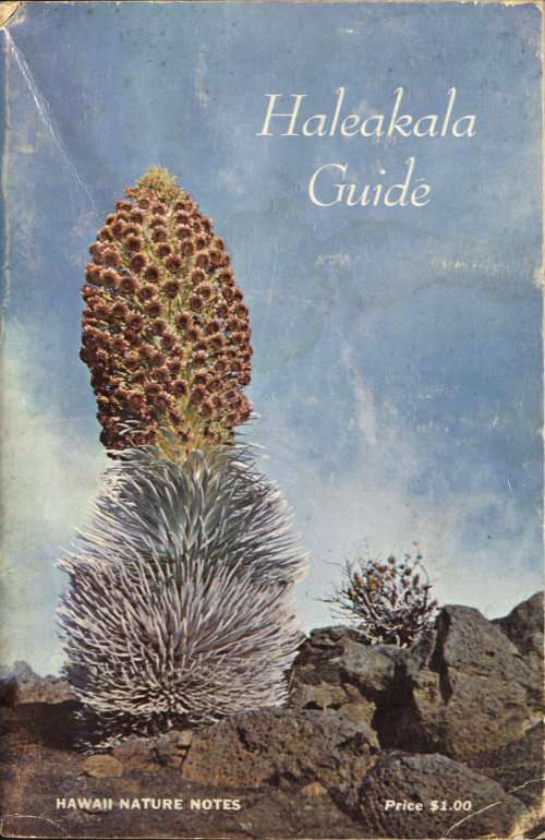
Covers: Silversword in bloom
HAWAII NATIONAL PARK
A Guide for the
Haleakala Section
Island of Maui, Hawaii
by
George C. Ruhle
illustrated by Donald M. Black
PUBLICATION OF THE
HAWAII NATURAL HISTORY ASSOCIATION
JUNE, 1959
On the Sliding Sands Trail
Preface
Most of us yearn to travel, and the preliminary to travel is to choose a place that others, people or books, say is interesting, then find out more about it.
This guide is to help you find out more about Haleakala. It is neither a reference book nor a treatise. It sums up what many have studied and observed. It skims over the myths that the mountain itself created in the imagination of old Hawaiians. It reflects also the labor and thought of the compiler. Its aim is to satisfy your interest while you are here on the brim, or at some other point. For some of you it may be the start of a deeper curiosity, to be satisfied by further reading elsewhere.
Think of this booklet as a chatty companion along the way, and a ready reminder after you have left, of your pleasant experience at Haleakala.
The system of 29 National Parks contains areas of superlative scenic and scientific grandeur essentially in the primitive state. The National Park Service of the Department of the Interior administers these, as well as 152 other areas of outstanding national significance. The law of the land enjoins us to use them in such manner that they may be passed unimpaired for the enjoyment of future generations.
The story of HAWAII NATIONAL PARK is the story of active volcanism singularly marked by eruptions of very fluent lava. The park is in two sections; that on the island of Maui, discussed in this guide, includes the great eroded crater of Haleakala Volcano; that on the island of Hawaii embraces the summits of Mauna Loa and Kilauea Volcanoes.
HALEAKALA
The silversword is the pride and distinction of Haleakala.
Haleakala is a great volcano, 33 miles long and 10,025 feet high. During a long period of inactivity, stream erosion cut two deep valleys, Keanae and Kaupo, into its sides. These joined near the summit. When volcanic activity once again resumed, flows of aa and blankets of cinders were spread on the valley floors. A multicolored cover, emphasized by symmetrical cones, formed the new floor of the depression, now loosely called Haleakala Crater.
The well chosen name, Hale-a-ka-la, means House of the Sun. Old Hawaiians associated Maui, a trickster demi-God, with the mountain. He was a legendary figure throughout Polynesia long before a few of its inhabitants discovered and settled in Hawaii, bringing their gods with them.
How Maui brought down or ensnared the sun has several versions. Maui’s mother, Hina, had trouble drying bark cloth, kapa, because the day was too short, its warmth insufficient. The sun just sped too fast across the sky. So Maui fashioned a strong net to snare it in its course. A slight variant, possibly less used, appeals more strongly. In early dawn, one can watch strong streamers of light from the rising sun break through the clouds and stalk across the crater. With these spidery legs the sun progresses through the heavens. As one by one they were placed over Koolau Gap, Maui seized them and bound them with strong thongs to an ohia tree. Thus captured, the sun pleaded for release. This Maui granted on promise of a slower gait, for which Hina as well as the rest of us can be eternally thankful.
Table of Contents
- Page
- Preface iii
- Haleakala iv
- PART I
- Your Vacation in the Haleakala Section 1
- Access 1
- What to do and see 1
- Hosmer Grove Campground and Picnic Area 2
- The Trail System 4
- Park Cabins 4
- Suggested Hiking Trips 5
- An Outfit for Hiking in Haleakala Crater 7
- Horseback Crater Trips 7
- Numbered Points of Interest on the Map 8
- PART II
- Haleakala Hawaiiana 16
- Maui Legends 16
- The Legend of Kihapiilani 18
- The Tradition of Kaoao 21
- Archeological Study 22
- The Historical Background 24
- Important Dates 36
- Geology 42
- The Origin of the Scenic Features 42
- The Geological Interpretation 46
- Haleakala Plants 49
- Plant Notes 55
- The Ferns 55
- The Native Grasses 56
- The Sedges—Fig. 1 56, 71
- Rush 57
- Painiu 57
- Mauu-laili 57
- Orchids—Fig. 2 58, 71
- Alaalawainui 58
- Sandalwood—Fig. 3 58, 72
- Sheep Sorrel 58
- Hawaiian Buttercup 59
- Hoawa 59
- Hawaiian Hawthorn 59
- Hawaiian Raspberry—Fig. 5 59, 73
- Mamane—Fig. 4 60, 72
- Nohoanu—Fig. 6, 7 60, 74
- Hawaiian Holly 60
- Olomea 61
- Aalii—Fig. 8 61, 75
- Begonia 53, 61
- Tarweed 61
- Ohio Lehua—Fig. 9 62, 75
- Evening Primrose 62
- Apeape 54, 62
- Olapa—Fig. 10 62, 76
- Ohelo—Fig. 11 62, 76
- Pukiawe—Fig. 12 63, 77
- Kolea—Fig. 13 63, 77
- Selfheal 63
- Puaainaka 63
- Groundcherry 63
- Plantain 64
- Kukaenene—Fig. 15 64, 79
- Pilo—Fig. 14 64, 78
- Manono 64
- Catchfly—Fig. 16 65, 79
- Oha 65
- Naupaka 65
- Maui Wormwood—Fig. 17 65, 80
- Kookoolau 66
- Kupaoa—Fig. 18, 19 66, 81
- Pamakani 67
- Hairy Cat’s Ear 67
- Wood Groundsel 68
- Tetramalopium—Fig. 20 53, 68, 82
- Silversword Cover, iv, 47, 68
- Summary Lists 70
- The Birds and Mammals 83
- The Insect Life 85
- Hawaiian Words and Place Names 89
- Hui O Ahinahina 93
- Additional Help 93
- Mileages Inside back cover
- Map Center Pages
YOUR VACATION
Anticipate a restful, invigorating interlude. Islanders consider vacation on the cool mountain an inexpensive, pleasant variant from a mainland trip.
Silversword Inn at an elevation of 6,800 feet is popular with luncheon guests and with those staying overnight to view sunset or sunrise from the summit of the great mountain. Attractive, friendly, comfortable, it is the loftiest hostelry in the islands. There is no formal atmosphere: warm, casual clothing is worn; it is strictly “come in as you are.”
Hiking and riding in the vicinity of the inn are favorite pastimes. Adjacent groves of trees of the Temperate Zone impart an aspect novel to the islands. A visit is highlighted by trips into the crater and to the summit, less than thirty minutes distant by car. The cup runneth over for photographers and nature enthusiasts. You can enjoy cool, restful nights between daytime drives to the many points of interest on Maui. For further details, reservations, and rates, consult the Manager, Silversword Inn, R.R. 53, Waiakoa, Maui, Hawaii, or Mr. William S. Ellis, Jr., 900 Nuuanu Ave., Honolulu 17, Hawaii.
ACCESS
The Haleakala road climbs through plantations and ranchland from Kahului Harbor and Kahului Airport to the park entrance at an elevation of 6,740 feet. The distance by the shortest route is thirty miles. The highway continues eleven miles further to the Park Observatory on the western rim of Haleakala Crater and to the 10,025-foot summit. No bus service exists, but taxis and U-drive cars are hired at the airport and in the towns of Kahului and Wailuku. The sole access into the crater is over good trails for travel on foot or by horse.
WHAT TO DO AND SEE
The start of a drive to the park is made by one of three paved routes. The shortest is Pukalani Road. The other two turn inland at Paia or Haiku and traverse more interesting country. The three routes converge at Pukalani Junction ten miles up the mountain. PUKALANI means a hole in heaven, which picturesquely describes the fact that the sun breaks through at this place despite a general overcast elsewhere.
As the road rises up and ever up, it unfolds distant views of fields of sugar cane and pineapple, of West Maui Range, 6,000 feet high, and of Molokai, Lanai, Kahoolawe, and Molokini Islands beyond channels of blue sea. 100 miles southward, the tops of the snowy volcanoes on the Island of Hawaii float on billowy clouds. 10,000 feet below, the aquamarine Pacific fringes Maui with white surf.
Three viewpoints along the road overlook the great crater: Leleiwi, at the 9,000-foot switchback; Kalahaku, two miles below the summit: and the Park Observatory, near the top. The roadway extends along the crest one mile southwestward to a scenic point beyond the park boundary and a communication station of the Civil Aeronautics Administration.
Just above the park entrance, Silversword Inn, a National Park concession, offers meals, rooms, souvenirs, horseback riding and guided horseback trips into the crater. Across from the inn, a paved spur road leads a half mile to Hosmer Grove Campground and Picnic Area.
Haleakala Crater is a favorite with those who like the back-country; its inspiring scenery and restful solitude are great reward for time and effort. The National Park Service maintains three cabins on the crater floor and 30 miles of well-marked trails for hikers and horseback parties.
HOSMER GROVE CAMPGROUND AND PICNIC AREA
A quarter mile above the park entrance, opposite the driveway to the inn, a paved lane, one-half mile long, leads to the Hosmer Grove Campground and Picnic Area. It has a shelter for rainy weather that contains two tables and two charcoal burners. Four additional tables with adjacent charcoal burners are in an open site below the road. Running water, parking space for eight cars, and sites for pitching tents are provided. Charcoal may be purchased at the inn. A self-guiding nature trail leads through the grove.
HOSMER GROVE
CAMPGROUND AND PICNIC AREA
The grove was named for the first Territorial forester, Dr. Ralph S. Hosmer, who experimented with planting temperate trees at high altitudes on Haleakala and Mauna Kea. Trees, planted here in 1910, include the deodar, Cedrus deodara from the Himalayas; the tsugi, Cryptomeria japonica from Japan; eucalypti from Australia; and from the mainland a cypress, Cupressus arizonica; a juniper, Juniperus virginiana; Douglas fir, Pseudotsuga taxifolia; incense cedar, Libocedrus decurrens; two spruces, Picea canadensis, P. excelsa; and seven pines: lodgepole, Pinus contorta, Coulter or big-cone, P. coulteri, Jeffrey, P. jeffreyi, longleaf, P. palustris, ponderosa or western yellow, P. ponderosa, white, P. strobus, and Scotch, P. sylvestris. Many of these have survived and have borne fruits. The huge keeled cones of Coulter pines are cherished as ornaments in some homes.
Native plants associated with the area are the shrubs: Haleakala sandalwood, mamane, pukiawe, aalii, mountain pilo, ohelo, silver geranium, kupaoa; two or three ferns; two sedges; and three native grasses.
Two thirds of the distance to the grove, the crater trail from the inn starts up the mountain to the left. This is a connecting link, 1¾ miles long, to the Halemauu Trail which it joins a half mile below its start on the highway. See Numbered Points of Interest, No. 9.
THE TRAIL SYSTEM
The Sliding Sands Trail, the popular route into the crater, starts from the parking area at the Observatory. It is constructed along the south side of the crater to Kapalaoa Cabin six miles away. Connecting trails go to Paliku Cabin, four miles farther. The Halemauu Trail has two upper ends, at the 8,000-foot elevation on the highway and on the Hosmer Grove Campground Spur near Silversword Inn. Halemauu Trail goes down Leleiwi Pali, the west wall, to Holua Cabin, four miles from the road or six miles from the lodge. The trail continues easterly from Holua for six miles along the north side of the crater floor to Paliku. Branch trails are built to points of interest. The Kaupo Trail through Kaupo Gap leaves Paliku Cabin and the crater to make a rapid descent of the southern, sun-drenched slope.
PARK CABINS
Each of the three visitor cabins within the crater, Kapalaoa, Paliku, and Holua, is equipped with running water, a wood-burning cookstove, firewood, kerosene lamps, cooking and eating utensils, twelve bunks, mattresses, and blankets. Use of these cabins by hikers on a priority reservation basis is granted free of charge by the Park. In consideration for their use cabins should be left clean and in order by each party. The following arrangements are necessary: write the Park, giving an outline of your proposed trip, number in the party, exact calendar dates, and names of specific cabins which you wish to use each night. The address is: “Hawaii National Park, Haleakala Section, P. O. Box 456, Kahului, Maui, Hawaii.” Cabin reservations can also be made by telephoning the Park. When you arrive in the Park, stop at the Administration Building for your permit, cabin key, and orientation.
SUGGESTED HIKING TRIPS
For safety reasons, all visitors are required to obtain permits from the rangers for all trips into the crater, other than those with Silversword Inn guides.
Short Walks for the Day Visitor: (1) Along Halemauu Trail from the highway to the Crater Rim, three-quarters of a mile. Views down Keanae Valley, across Koolau Gap to Hanakauhi, and of Halemauu Trail. (2) A short distance down the Sliding Sands Trail. Be careful not to travel too far down. The return climb is exhausting at this high altitude. (3) To the top of White Hill. The trail winds among ancient Hawaiian stonewalled encampment sites.
One-day hikes into crater: (1) Down Halemauu Trail to Holua Cabin and return to the highway, a scenic trip of eight miles that can be taken by any reasonably good hiker. It is not recommended when clouds blanket the pali and Koolau Gap. Allow a half-day for hiking. (2) Down Sliding Sands Trail to the crater floor, across Ka Moa o Pele Trail to Halemauu Trail at Pele’s Paint Pot or Bottomless Pit, and return to the highway via Holua and the Halemauu Trail. This colorful, spectacular twelve-mile trip is recommended only for good hikers. Allow eight hours of hiking time. At your risk, rangers can often arrange to move your car for you to the place at which the Halemauu Trail emerges on the highway.
Overnight crater hikes: Hike down Sliding Sands Trail; spend the night at either Paliku, Kapalaoa, or Holua Cabin; return via Halemauu Trail. The choice overnight hike to Paliku, a 20-mile round-trip, is recommended for good hikers only. The trip with an overnight stop at Kapalaoa is 14 miles long. The shortest route from the foot of Sliding Sands Trail to Holua via Ka Moa o Pele leaves only the four-mile climb via Halemauu Trail for the second day. The Sliding Sands Trail is not recommended for return from a crater trip. The long climb to an elevation of 10,000 feet is too exhausting for most people.
Two and three day crater hikes: Entry via the Sliding Sands and return via Halemauu Trail is recommended. A three-night trip stopping at Kapalaoa, Paliku, and Holua allows leisurely enjoyment of the crater. Good health and fair walking ability are all that are required for these longer trips.
1. Koolau Gap; 2. Waikau; 3. Hanakauhi Peak; 4. Paliku; 5. Puu Maile; 6. Kaupo Gap; 7. Haleakala Peak; 8. Puu Kumu; 9. Puu Naue; 10. Ka Moa o Pele; 11. Puu o Maui; 12. Kamohoalii; 13. Ka Lua o ka Oo; 14. Puu o Pele.
No guide service is available or necessary for parties hiking or riding their own stock into the crater. However, a permit is required before you start your trip within the crater. For details, consult the section labelled “Park Cabins.”
AN OUTFIT FOR HIKING IN HALEAKALA CRATER
Clothing should consist of hiking shoes, slacks, shirt, jacket, hat, and preferably a light raincoat. Basketball shoes or keds are preferred by some. Because of the chill climate at elevations of seven to ten thousand feet, warm clothing is advisable. In climbing, temperature goes down as you go up. The top of Haleakala averages thirty degrees cooler than sea level. You should bring your food for the trip, a knapsack, sunburn lotion, soap, hand towel, dish towel, matches, and simple first aid. As cooking facilities in the cabins are adequate, food need not be precooked.
HORSEBACK CRATER TRIPS
Silversword Inn provides horseback trips on good stock with a competent guide. Food is provided, cooking is done by the guide, and sleeping accommodations are arranged by the management. A guest need only concern himself about personal effects and clothing suitable for riding in a cool climate. For rates and trip reservations, telephone or write to the Manager, Silversword Inn, R.R. 53, Waiakoa, Maui, Hawaii, or to Mr. William S. Ellis, Jr., 900 Nuuanu Ave., Honolulu 17, Hawaii.
If you have your own horses make the same arrangements as hikers for entry into the crater and for cabin use. You may travel on any of the crater trails. Fenced horse pastures are adjacent to each of the cabins.
NUMBERED POINTS OF INTEREST ON THE MAP
Basic data for this section was compiled by the park staff and submitted by Eugene J. Barton, Assistant Superintendent in charge of Haleakala from 1949-1955. The map is in the center of the booklet.
1. Park entrance (elev. 6,740′) and inn: The park entrance, marked by a rustic sign, is on the slope of Puu Nianiau, an ancient cinder cone. Nianiau is Hawaiian for swordfern. One quarter mile above the entrance turn right to the Silversword Inn for meals, lunches, overnight accommodations, color pictures, slides, and souvenirs of the park. The inn arranges guided trips through Haleakala Crater.
2. Ralph S. Hosmer Grove: Across from the lodge, a paved spur road leads to the Hosmer Grove Campground and Picnic Area.
3. Headquarters of the Haleakala Section of Hawaii National Park: Stop at the Administration Building beside the road for information, permits, cabin keys needed on crater trips, and for assistance in case of trouble or accident. The park maintenance area is located behind the station. As you drive toward the summit, note the small native trees and shrubs growing along the road. This elfin forest was all but destroyed by goats and cattle; it has recovered under National Park protection. The book, “Plants of Hawaii National Park,” and the section on plants in this guide may help you identify the different species. These and other publications of the Hawaii Natural History Association may be purchased at the inn or at Park Headquarters.
4. Leleiwi Overlook; Kalahaku Overlook: At the switchback near the 9,000-foot contour, a parking space has been constructed that is labelled LELEIWI OVERLOOK. This is above Holua and the Halemauu Trail, so that parties can be watched as they go down Leleiwi Pali. On clear days, the whole length of Keanae Valley can be seen through Koolau Gap. The lateral view extends from Hana Airport across the big isthmus to Kihei on Maalaea Bay. On afternoons, clouds roll into the gap, making this a good place to see the Brocken Specter. One’s shadowy image appears within a circular rainbow, projected against the bank of cloud. KALAHAKU OVERLOOK (elev. 9,325′) is a remarkable view point on the crater rim that is reached by a short spur off the main park road. It is the site of the Old Rest House, in which travellers on foot or horseback stayed overnight before the road was built. Silversword plants may be seen just below the main parking area. KALAHAKU is the name of the rugged pali forming the crater wall at this point. The name means “meeting place of the headmen or chiefs.”
5. The Observatory commands a spectacular view of the crater near the summit of Haleakala. It was erected in 1937 by the National Park Service for your comfort and convenience. The observatory is the main objective of most visitors to Haleakala. Besides being a welcome shelter during inclement weather, it has a large relief map and interpretive orientation devices. Modern rest rooms are located to the rear of the building.
6. White Hill, Pakaoao (elev. 9,865′); start of Sliding Sands Trail: The rocky hill, just above the observatory, is capped with andesite, a volcanic rock lighter in color and different in composition from the common basaltic lava of Hawaii. The southwest slope, up which the trail leads, is covered with Hawaiian sleeping shelters consisting of oval stone-walled enclosures. These gave protection against the wind, fog, and cold that is common here. They may have been used long ago by wayfarers or by sentries and groups of warriors stationed at this commanding site. They may also have served as ambush for professional robbers, aihue, who waylaid travellers in lonely places. Refer to the topic, “The Tradition of Kaoao” in “Haleakala Hawaiiana” for more of the story.
7. Red Hill, Pakaoao, Summit of Haleakala (original English name, Pendulum Peak; elev. 10,025′): To drive to the summit take the paved road, turning sharply left below the observatory parking area. Red Hill is the highest of the three prominent recent cinder cones. Early morning is a good time to view extended panoramas and distant seascapes, before streaks of clouds form shelves along the sides of the mountain. But afternoon is better for viewing the crater, as its features appear in excellent light and color at that time. A pointer table by the road indicates the names of islands and peaks seen. An Army radar and radio communication station was located on Red Hill during World War II.
Halemauu Trail on Leleiwi Pali.
8. Skyline Drive: An improved driveway to the Civil Aeronautics Repeater Station leaves the park at the pass between Red Hill and Kolekole. Views stretch down the vast, precipitous southwest outer slope of Haleakala to the Lualailua Hills and a desert seashore, ten thousand feet below. Morning will most likely yield the cloud-free views. The Aeronautics Station is open to visitors. A parking area is just outside the gate to the station. Kolekole is the site of television relays and a satellite tracking station. It is a mile from the Observatory to the summit of Kolekole. It is 1.7 miles from the Observatory at the FAA Station. Magnetic Peak is across the road from Red Hill. A huge curiously shaped bomb on its skyline has a silhouette that looks much like a sitting duck.
Volcanic bomb on Magnetic Peak.
9. The Halemauu Trail starts from a curve on the park road at the 8,000 foot elevation. It leads down a gentle slope for eight-tenths of a mile to the crater rim. An alternate start is on the driveway into Hosmer Grove Campground, near Silversword Inn. Built by the National Park Service in 1937, the trail drops with a gentle grade down the 1500-foot Leleiwi Pali to the crater floor. It suggests thrilling trails in Glacier National Park and other rugged mainland areas as it swings and clings to the vertical cliffs. Hike to the crater rim for spectacular views of Windward Maui and Keanae Valley in fair weather; if clouds are rolling up Koolau Gap in the evening, you may possibly be greeted by the Specter of the Brocken. Silver geraniums, Hinahina, small spherical shrubs peculiar to Haleakala, grow along the upper trail and road. HALEMAUU, grass house, is said to be derived from one formerly located near the head of the trail.
10. Holua Cabin rests in a grassy plot at the foot of the towering, 3,000-foot Leleiwi Pali. Introduced grasses grow in the meadow near it. The pale “moss” on the rough lava flow is Stereocaulon, actually a lichen, that strange combination of an alga and a fungus growing together to appear as one plant. This pioneer on barren new lavas is sometimes called Hawaiian Snow. The comparatively recent flow in front of the cabin contains lava tubes or caves. These are rough and dangerous, and should not be entered except by especially equipped parties. Holua Cave, above the cabin, was used as a night shelter before the cabin was built.
11. Silversword Loop, a quarter-mile long, deviates from Halemauu Trail past several clumps of silversword. Hollows and slopes of the old, weathered, red lava flow in this area have favorable conditions for their growth. Near the east end of the loop, the main trail passes among many piles of stones, ahus, markers, and platforms built by the Hawaiians. This place, known as KEAHUOKAHOLO, appears to have had special or sacred significance. State law, as well as Hawaiian customs and ethics, strictly forbids disturbing or damaging any of these ancient structures.
12. Kihapiilani Road: From a black, cinder-covered flat, an old Hawaiian pathway crosses the rough shoulder of the small cone on Halalii to smoother surface between Mamane Hill and Puu Kumu. It is six to eight feet wide and is paved with flat stones. The start, difficult to locate, is to the right of a small, horned spattercone seen from the trail as you look toward Hanakauhi Peak. A chief, Kihapiilani, built the trail over Mauna Hina along the North Rim to a pond, Wai Ale, probably the present Wai Anapanapa on the exterior slope. Refer to “The Legend of Kihapiilani” in “Haleakala Hawaiiana” for the story.
13. Bottomless Pit is a yawning black well, ten feet in diameter, rimmed with colored lava spatter a few feet high. Use caution approaching its edge. Baseless legend claims that it sinks to sea level. Although no bottom can be seen, debris chokes the opening sixty or seventy feet below. It is a vent, through which superheated gases were emitted in an eruption of long ago. The rim around the throat indicates that a little lava sputtered out with the gas. During the flank eruptions of Mauna Loa and Kilauea similar vents exhale columns of blue, incandescent gases at intervals. Old Hawaiians at Kaupo say that the pit was used for disposition of umbilical cords of babies. Various reasons are assigned to the custom, such as to make the child strong, or to prevent its becoming a thief.
14. Ka Moa o Pele Trail branches from the foot of the Sliding Sands Trail to join the Halemauu Trail across the crater. It is a scenic route between silverswords on Ka Moa o Pele, a red cinder cone. Flowering plants can usually be seen from June to September. Pa Puaa o Pele, Pele’s Pig Pen, is the rim of a spatter cone, now buried, in the low pass between Halalii and Ka Moa o Pele. Hikers from Sliding Sands to Holua should go around the right or east side of Halalii to see the Bottomless Pit and Pele’s Paint Pot, a colorful pass just a short distance beyond.
15. Bubble Cave is a large, collapsed bubble with heavy walls. It was blown by gases in ancient molten lava. Only a small segment collapsed in the center of the roof, which serves as entrance and smoke-hole; old-timers were wont to camp in this natural shelter. It was the rest stop now supplanted by Kapalaoa Cabin.
16. Wailuku Cabin, outside the park, was built by the State Board of Agriculture and Forestry for the use of hunters. Arrangements for its use must be made at the Maui Office of the Board in Kahului. Trails to it are not of park standards and are not recommended to sightseers.
17. Old and New Volcanics: Dikes that protrude as slabs of light-colored rock from slopes of the ridge toward Hanakauhi mark part of the ancient divide between Koolau and Kaupo Valleys, the great erosional canyons worn into the mountain during an age of quiescence. This divide is deeply buried inside the crater under the cinders and flows of renewed eruptions that form the present floor. Adjacent Mauna Hina and Namana o ke Akua, green with shrubs, grass, and scrub mamane, are cinder cones from ancient eruptions. Puu Nole, a garish, black youngster in the community, has only silverswords on its barren slopes. Towards Paliku the trail is flanked by some of the most recent lava flows, only a few hundred years old. Their source vents are visible on the slopes of Hanakauhi and the north wall of the crater.
18. Lauulu Trail is plainly visible as it zigzags up the north wall. Although not maintained at present, it is passable and allows rugged enthusiasts to climb the rim for views of the crater. On the outer slopes, moist grassy plots, often fog-bound, blend into jungle that drops to the Hana Coast, 8,000 feet below. Kalapawili Ridge extends from the summit of Hanakauhi Mountain eastward around the head of Kipahulu Valley to the tiny lake, Wai Anapanapa. It is readily traversable for the good hiker.
19. Paliku is very different from the desert wastes in the other parts of the crater. Lush grass and ferns, overhanging forest trees, and a verdant cover on a towering pali result from abundant clouds pushed by the trade winds over the east wall. AKALA, the giant Hawaiian raspberry, ripens abundantly back of the cabins in July. It is excellent for pie, conserves, or dessert. Native Hawaiian trees include: MAMANE, far larger than the scrubby growth in the crater; OHIA, with gray-green leaves and red lehua flowers; KOLEA, with thick magnolia-like leaves four inches long; OLAPA, with leaves that tremble in the slightest breeze, like those of quaking aspen. The conifer above the Ranger Cabin is a cryptomeria, a Japanese evergreen planted early in this century.
20. Kipahulu Valley, beyond the eastern rim, is a remote, jungle wilderness walled in by loftiest cliffs; a no man’s land, it has barely been explored, let alone touched or altered by civilization. Look from the cabin at Paliku across the pasture to the lowest notch in the sheer eastern pali. For a view into Kipahulu, a good climber can follow an old goat trail, steep and tortuous, that leads up the left side of the draw to this notch. A chorus of bird songs rises from the primeval forest in Kipahulu. With them you may hear complacent squeals of wild pigs that have been undisturbed for generations.
21. Kaupo Trail is a good trail that winds down Kaupo Gap, across little meadows, through groves of small AALII trees, and under spreading KOA trees to the park boundary which is below the 4,000-foot contour. Wild goats may be heard on the pali or on the lavas in the gap. Kaupo Ranch extends below the park. From the redwood water tanks, a jeep trail descends through pastures to ranch headquarters. It is 8 miles from Paliku to ranch headquarters, which can be hiked in a half day. Kaupo Village on the belt road around Haleakala is 1½ miles further. The route is interesting, but arrangements must be made in advance to be met by car either at the ranch or the village. It is fifty miles from Central Maui by the shortest road. Although Kaupo Trail crosses private property, advance permission is not required to use it; but, in due consideration, please use care to close gates and do not molest or damage any property. The reverse trip from Kaupo Village into the crater is not recommended because of the long, arduous climb up the unsheltered, south-facing mountain slope.
Paliku Cabin.
HALEAKALA HAWAIIANA
MAUI LEGENDS
Thus starts the story of Maui, beloved demi-god of all Polynesia in the never-never land of long ago. Not wanted as a babe, for he was scrawny and deformed, his mother, Hina, wrapped him in a lock of her hair and cast him into the sea. But jellyfish rescued and mothered him, and the god, Kanaloa, gave him protection. For all that, the growing youngster yearned for his own, so that one day he crept back and stealthily mingled with his four brothers. He was accepted in the family circle only after much pleading by the eldest boy.
Maui-of-a-thousand-tricks is the favorite nickname given this delightful, oft thoroughly human scamp. Throughout his escapades he was ever faithful to man, so frequently fickle and unworthy. Maui made the birds visible, for at first they could only be heard as they sang and fluttered through the air. Maui invented spears and barbed fishhooks. His greatest catch, so runs his fish story, was with a huge hook of powerful magic made from the lifeless jawbone of his grandmother, who was remarkable, for only one side of her body was alive. He tricked his brothers into the task of manning the paddles while he, equipped with his potent tackle, fished up the Hawaiian Islands from the depths of the ocean. Maui first had strictly admonished the brothers not to watch him, but only to look straight ahead. When curiosity overcame the belabored paddlers, they disobeyed. The line parted as they looked back, leaving the land only partly emerged, a chain of islands instead of a continuous whole.
The story of the island of Maui thus begins and—so runs one version—Maui lived in plain fashion on simple fare in a humble grass hut at Kauiki, the famous foothill of Haleakala in the district of Hana. Hawaii at the time was covered by darkness and fog, so Maui pushed the heavens to their present position far above the highest mountains, Haleakala, Mauna Kea, Mauna Loa, and Hualalai. Before this feat, man had to stoop and crawl, pressed closely to the ground, for the skies were low, and were held up by the plants whose leaves became flattened by their burden, even as they remain today. Yet even now, when Maui is asleep, the heavens rush back as somber clouds and darken the country with storms. From Kauiki, Maui made his important journey to the crater to capture the sun and force it to move slowly through the heavens that tapa may be dried and fruits can mature. Also there are more daylight hours for fishing and ceremonial preparations in the heiau. This legend, the most pertinent to this guide, is sketched in the Introduction to Part I.
Most Hawaiian legends place Maui’s home in the black lava bank of the Wailuku River above Hilo, while his mother chose the dark cave behind Rainbow Falls. His exploits, so often capricious, more frequently reflect a benefactor’s concern for mankind. Maui disclosed the art of making fire by rubbing sticks together. Previously, man was dependent on Pele’s volcanic furnace or on embers carefully nurtured to kindle his fires. Maui wrung the secret from Alae, the reluctant mud-hen, who alone knew it and guarded it with greatest care. Exasperated by repeated frustration and deception, Maui, once he had gained her secret, punished the stubborn bird by rubbing her head with a stick so roughly that all the feathers came off and raw flesh appeared, which is how it remains today.
Maui in his noblest moment gave his all for man, whose frailty brought about the downfall of both. For Maui, too, was doomed to die some day, since his father, like Achilles’ nurse Cynosura, had neglected a part of the proper ceremony to make him immortal. Maui abhorred the fact that man must die, for he regarded death as degrading and an insult to the dignity of man. The secret of life was hidden within the heart of Hina-nui-kepo, the dread ogress of death. To win immortality one had to steal through her jaws, which had sharp basalt teeth, enter into the inky blackness of the stomach, and tear out the heart. This could only be done while Hina slept. First, Maui turned man into a little bird, and advised him to keep very quiet, lest he awaken the fearful goddess from her slumber. Then he went stealthily about his fearsome task, speedily and alone. All went well until the return journey; alas! poor, weak man could not restrain himself, but burst into uncontrollable laughter as he watched the plight of the demigod within the ugly, gaping fish-mouth of Hina. The great jaws closed with a snap that crushed Maui and left Death ever after the victor. Greater love hath no man!
It would seem that the crater so high in the sky, so remote in location, so difficult in access, so desolate in appearance, so dread in origin, should have been shunned by the early native. Quite the contrary, many marks of frequent and varied use may be discovered in the crater. A trail through it connected the busy sites on West Maui and the isthmus with Kaupo and Hana near the eastern shore. This direct route avoided the wet heavily forested northern slopes of the mountain as well as the precipitous, arid, rough terrain on the southwest. It was easily traversed, in spite of the climb involved.
THE LEGEND OF KIHAPIILANI
“Kihapiilani was one time King of Maui. It was he who caused the road from Kawaipapa to Kahalaoaka to be paved with smooth rocks, even to the forests of Oopuloa in Koolau, Maui. He also was the one who built the road of shells on Molokai.” “And,” the great Hawaiian antiquarian, Abraham Fornander, might have continued, “he caused the trail across the crater of Haleakala to be paved with water-worn stones, to the foot of Hanakauhi of the mists.” Kihapiilani was the great public works king of the islands.
Because of Kihapiilani a most remarkable event of ancient Hawaiian history came to pass, the expedition of numberless canoes.
Three and a half centuries ago, Piilani, a king of Maui, had four children: two sons, Lonoapii who was the eldest child, and Kihapiilani, the youngest; and two daughters, Piikea, who became the wife of King Umi of Hawaii, and Kihawahine, now regarded as the lizard god. When the old king was dying, he adjured his successor, Lonoapii, to take his place as father and to be kind to the younger brother. But alas, the young prince was neglected and treated with contempt. One day at Waihee, two calabashes of small fish, nehu, still wet with sea water, were brought to Lonoapii. These he gave to everybody except the younger brother, who, therefore, reached out and helped himself. This angered the king so that he hurled the calabash and its contents into Kihapiilani’s face. Without a word, Kihapiilani arose and travelled to Kula. After some time, he told his story to the kahuna Apuna and asked what he should do. Apuna replied that he should seek advice at Keanae from a kahuna named Kahoko. Kahoko sent him to Hana, and from there to Hawaii, following a certain dark object as guide. Kihapiilani and his retinue travelled the windward side of Kohala on foot, swimming through shark-infested waters around the bold headlands. Everywhere people gathered to him, for he was handsome and brave. When he reached Laupahoehoe, in Hamakua, he found his sister, Piikea, living with her husband, Umi. Umi had already become a great chief for he had overthrown his tyrant brother, Hakau, but his greatest deeds were yet to follow. These include the union of all of the island of Hawaii under his rule.
When Kihapiilani explained that he was seeking someone to avenge him, for Lonoapii had thrown salt water into his face, Piikea goaded Umi to help him, for he had crossed the seas. So Umi sent messengers with orders that koa be felled and many canoes made ready for the crossing to Maui. These were so numerous that when the first canoe reached Kauiki, the last were still in Waipio. The sea was covered with canoes. Umi ordered the canoes to be fastened bow to stern by twos, and in this way the men walked across instead of sailing, the canoes being a dependable road. This is known in legend as the sailing of numberless canoes.
At Kauiki fortress the leader, Hoolae, fought bravely from the top of the hill in daytime, but at night he set a huge wooden image of a man with a bristling war club at the head of the ladder up which the attackers had to climb. The trick frightened away all approaching enemies, while the defenders slept in peace. One night, however, Piimaiwaa took his war club and approached the giant. He hurled insults at him from a safe distance. As his taunts drew no response or movement, Piimaiwaa twirled his war club, threatened with gestures, and gradually crept closer to discover the clever ruse that had fooled the forces of Umi. With that obstacle gone, Umi’s men surprised and slew the enemy. Hoolae was captured and killed on the eastern side of Haleakala. War spread over all of Maui, until Lonapii was slain at Waihee and Kihapiilani became king of the island. It could well be that during this campaign Kihapiilani became acquainted with our crater, across which he later constructed the paved trail, another monument to his reign.
Some believe that the trails paved with waterworn rocks were built by menehune, the dwarf race supposed to work secretively at night. Actually, the commoners performed the labor, being pressed into service for the task. They formed an endless chain from the coast, so that rocks could be passed from hand to hand until carefully fitted into place on the walkway. The spaces between the larger stones were often filled with sand or gravel.
The early Mauians had many names for different parts of the crater. Some places had two names; sometimes one name served more than one place. Thus there is duplication of use of the name Haleakala, for besides being the name of the whole volcano, it is also applied to the peak on the rim west of Kaupo Gap. Or could haole confusion have given rise to use for the whole mountain a name that once applied only to a prominence on the rim?