APPENDIX.
CHAPTER I.
NICARAGUA: BOUNDARIES, TOPOGRAPHY, LAKES, RIVERS, PORTS, CLIMATE,
POPULATION, PRODUCTIONS, MINES, ETC., ETC.
Nicaragua, while it remained under the Spanish crown, constituted one of the provinces of the ancient Audiencia or Captain-Generalcy, sometimes called the kingdom of Guatemala, in which were also included the provinces of Costa Rica, Honduras, San Salvador, and Guatemala.[44] These threw off their allegiance to Spain in 1821, and in 1823 united in a confederation called the “Republic of Central America,” which, however, in consequence of internal dissensions, was dissolved in 1839. Since that time, the several States have asserted and exercised their original sovereign powers as distinct republics. Several attempts have been made, at brief intervals, to revive the confederation, in whole or part, but without success, owing to the irreconcilable jealousies of the different States. A kind of understanding, almost amounting to a union, has nevertheless continued to exist between the three central States, Nicaragua, San Salvador, and Honduras, which are distinguished as Liberal and Republican, while Costa Rica and Guatemala, in the political classifications of these countries, are denominated Servile or Monarchical.
44. The large province, now State of Chiapas, included in the Republic of Mexico, also belonged to the old kingdom of Guatemala. After the independence, it was appropriated by Mexico, which, under the rule of Iturbide, endeavored to annex to itself the whole of Central America.
The boundaries of Nicaragua are those which pertained to it as a province, except in so far as they have been modified by subsequent treaties and concessions. As now defined, they are as follows: on the east, the Caribbean Sea, from Cape Gracias à Dios at the mouth of the Rio Wanks or Segovia, in lat. 15° N., and lon. 83° 12′ W., southward to the port of San Juan, at the mouth of the river of the same name.
On the south, the line of separation from Costa Rica, as fixed by a convention dated April 15th, 1858, starts from Punta de Castilla, or Punta Arenas, on the south shore of the harbor of San Juan, and thence follows the right bank of the river San Juan to within three miles of the old fort known as Castillo Viejo. At this point the line falls back two miles from the river, preserving that distance from the stream to the point whence it issues from Lake Nicaragua, following along the southern shore of that lake, at an equal distance inland, until it strikes the river Sapoa, flowing into the lake, and thence due west to the Bay of Salinas, on the Pacific.
On the west, the Pacific ocean, from the centre of the Bay of Salinas to the mouth of the Rio Negro, in the Bay of Fonseca, embracing about one-third of the coast-line of the Bay.
On the north, separating it from Honduras, a line following the Rio Negro from its mouth on the Bay of Fonseca, to its source in the mountains of Nueva Segovia, following the crest of the dividing ridge of the same to the head of the Rio de la Puerta; thence, due east, to the Rio Coco, Wanks, or Segovia, and down that river to its mouth at Cape Gracias à Dios.
The State is therefore embraced entirely between 83° 20′ and 87° 30′, (6° 20′ and 10° 30′ from Washington,) west longitude, and between 10° 45′ and 15° of north latitude; and has an area of about 50,000 square miles, or about an equal extent of territory with the New England States, exclusive of Vermont and New Hampshire.
A claim to a considerable part of this territory, embracing the entire Atlantic coast, and extending indefinitely inland, was set up, some years ago, by Great Britain, on behalf of the suppositious “King of the Mosquitos;” but there is now (1859) good reason for believing that the fiction of a Mosquito sovereignty will soon be abandoned, and the Mosquito Indians placed, by common consent, under the government of Nicaragua, with the sole reservation of their proprietary rights, or rights of occupation.[45]
45. For an exposition of the nature and extent of British pretensions, as also the political condition of the Mosquito Shore, and an account of the country and its people, see Chapter “Mosquito Shore,” in “States of Central America,” etc., pp. 628-663, and “Adventures on the Mosquito Shore,” Note A.
Placed on a narrow isthmus between the two oceans, its ports opening to Europe on one hand, and to Asia on the other, midway between the northern and southern continents of America, Nicaragua seems to realize the ancient idea of the geographical centre of the world. These geographical advantages are however, much heightened, and rendered especially interesting and important, from the interior and topographical features of the country, which are supposed to afford facilities for water communication between the seas, superior to those of any other part of the continent. These features are principally determined by two ranges of mountains which traverse the State in a direction nearly due north-west and south-east. One of these, which may be called the volcanic or Pacific coast range, starts in the high lands of Quesaltenango in Guatemala, and extending through San Salvador and Nicaragua, terminates in the great mountain group or nucleus of Costa Rica. It follows the general direction of the coast, sometimes rising in lofty volcanic cones, but generally sustaining the character of a high ridge, subsiding in places into low hills and plains of slight elevation. It preserves a nearly uniform distance from the sea of from ten to twenty miles; and, consequently, there are no considerable streams falling from it into the Pacific. It seems to have been the principal line of volcanic action, and in Nicaragua is marked by the volcanoes of Coseguina, El Viejo, Santa Clara, Telica, Axusco, Las Pilas, Orota, Momotombo, Masaya, Mombacho, Ometepec, and Madeira, and by numerous extinct craters, surrounded by vast beds of lava and deposits of scoriæ. The second, or principal mountain range, the great back-bone of the continent and the true Cordilleras, enters the State from Honduras, in the department of Nueva Segovia, and extends due south-east, until it strikes the San Juan river at a point about fifty miles above its mouth. It sends out numerous spurs or dependent ranges towards the Atlantic, between which flow down the many considerable streams that intersect what is called the Mosquito Shore.
Between these two ranges of mountains is formed a great interior basin, not far from three hundred miles long by one hundred wide, in the centre of which are the broad and beautiful lakes of Nicaragua and Managua—the characteristic and most important physical features of the country. These lakes receive the waters which flow down from the mountains on either hand, and discharge them through a single outlet, the river San Juan, flowing through a narrow break in the Cordilleras, into the Atlantic. Some of the streams falling into these lakes from the north are of considerable size, and furnish a supply of water, in excess of evaporation, which could not be sensibly affected by drains for artificial purposes.
Lake Managua is a beautiful sheet of water, not far from fifty miles long, by from thirty to thirty-five wide, and with a depth of water over the greater part of its area, varying from two to ten and fifteen, and even forty fathoms in depth. It approaches at one point to within fifteen miles of the Pacific, from which it is separated, on the south, by the volcanic coast-range already described, which here takes the form of detached hills, rising on a ridge of moderate elevation. But between its northern extremity and the sea, there are only the magnificent plains of Leon and El Conejo, separating which is a line of volcanoes, rising from the plain with all the regularity of the pyramids. The scenery which borders the lake is unsurpassed in beauty and grandeur. Upon its northern and eastern shores, lifting their blue, rugged peaks one above the other, are the mountains of Matagalpa, merging into those of Segovia, rich in metallic veins. Upon the south and west are broad and fertile slopes and level plains, covered with luxuriant verdure, and of almost unlimited productiveness. The volcano of Momotombo, like a giant warder, stands out boldly into the lake, its bare and blackened summit, which no man has ever reached, covered with a light wreath of smoke, attesting the continued existence of those internal fires which have seamed its steep sides with burning floods, and which still send forth hot and sulphurous springs at its base. Within the lake itself rises the regular cone of Momotombita, so regular that it seems a work of art, covered with a dense forest, under the shadows and within the deep recesses of which, frayed by the storms of ages, stand the rude and frowning statues of the gods of aboriginal superstition, raised there long before European feet trod the soil of America, and to which the mind of the Christianized Indian still reverts with a mysterious reverence.
The town or city of Santiago de Managua, which gives its name to the lake, and which is the place of meeting of the Legislative Chambers of the State, is situated on the south-western shore of the lake. The city of Leon was first built on the shore of the north-western extremity of the lake, at a place now called Moabita, but it was subsequently abandoned for the present site, in the midst of the great plain of Marabios, or Leon. From this circumstance, the lake in question is sometimes called Lake Leon. It was called by the aboriginal inhabitants of the country, Ayagualo.
Lake Managua has an outlet at its south-eastern extremity, called Rio Tipitapa, connecting it with Lake Nicaragua, through the Estero de Panaloya. This outlet, during rainy seasons of severity, passes a considerable body of water; but it is often completely dry, the evaporation from the surface of the lake exceeding the supply of water from its tributaries. The difference in level between the two lakes, at average stages of water, is twenty-eight feet six inches.
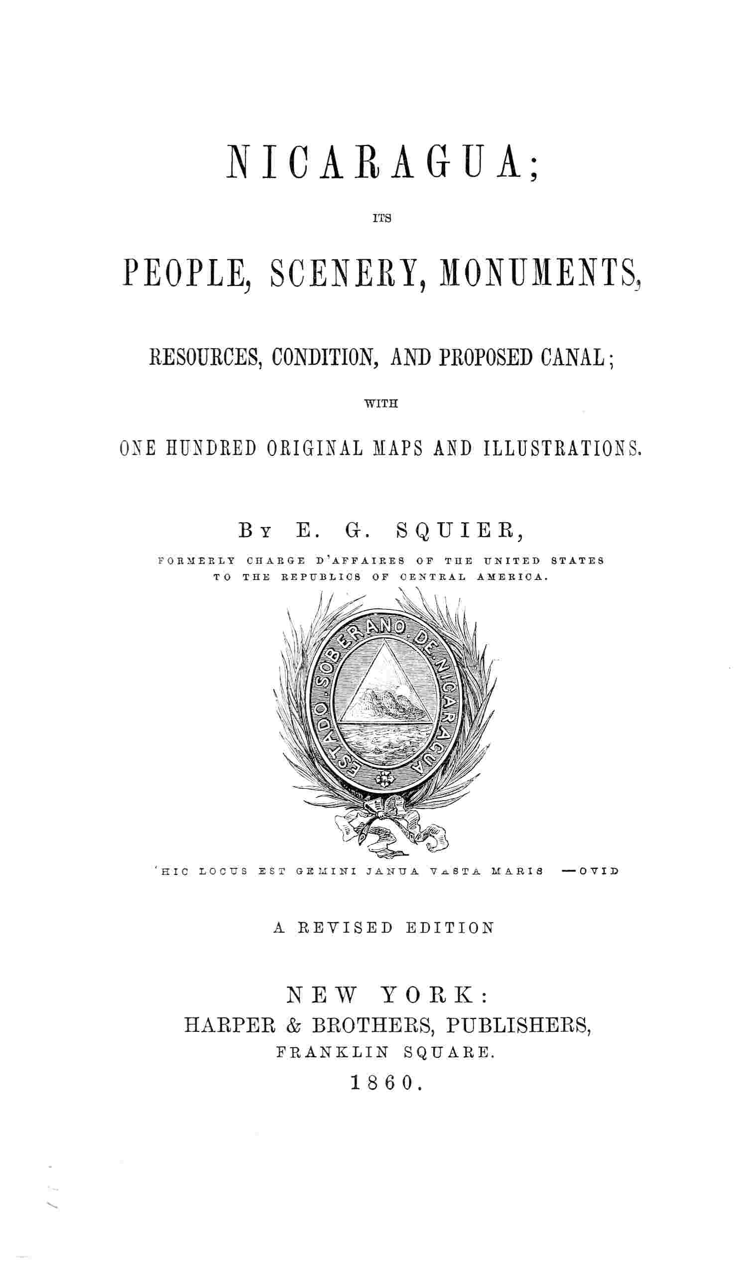
Lake Nicaragua, the ancient Cocibolca, is nevertheless the great feature of the country, and is unquestionably, in all respects, one of the finest bodies of water in the world, and second to none in the variety and beauty of its scenery. It is about one hundred and twenty miles in greatest length, by sixty in greatest, and forty in average breadth. On its southern shore, near the head of the lake, stands the ancient city of Granada, lately the rival of Leon, and once the most important commercial town in the republic. A few miles below Granada, and projecting boldly into the lake, is the extinct volcano of Mombacho, 5,000 feet in height. Studding the lake, at its base, is a cluster of innumerable small islands, called Los Corales, of volcanic origin, rising in the form of cones to the height of from twenty to one hundred feet, and covered with verdure. On the same shore with Granada, but forty miles distant, is the town of Rivas or Nicaragua, the capital of a large, fertile, and comparatively well-cultivated district. Flowing into the lake, at its extreme southern extremity, nearly at the same point where the Rio San Juan (the ancient El Desasuadero) commences its course, is the considerable Rio Frio, which has its origin near the base of the great volcano of Cartago, in Costa Rica. It flows through an unexplored region, inhabited by an unconquered and savage tribe of Indians, called Guatusos, of whose ferocity the most extraordinary stories are related.
VOLCANO OF OMETEPEC, FROM VIRGIN BAY.
The northern shore of the lake, called Chontales, for the most part is undulating, abounding in broad savannahs, well adapted for grazing and supporting large herds of cattle. There are a number of considerable islands in the lake, the largest of which are El Zapatero, Solentenami, and Ometepec. The former two are deserted, but the latter has a considerable population of Indians, of the pure Mexican or Aztec stock. This island is distinguished by two high, conical mountains or volcanic peaks, called respectively Ometepec and Madeira, which are visible from every part of the lake, and from a distance of many leagues on the Pacific. The name of the island, in the Nahuatl or Mexican language, signifies “two mountains,” from ome, two, and tepec, mountain. The water of the lake, in most places, shoals very gradually, and it is only at a few points that vessels of considerable size may approach the shore. Still, its general depth, for all purposes of navigation, is ample, except near its outlet, where, for some miles, it does not exceed from five to ten feet. There are points, however, where the depth of water is not less than forty fathoms. The prevailing winds on the lake, as indeed of the whole State, are from the north-east; they are, in fact, the Atlantic trades, which here sweep entirely across the continent and encountering the conflicting currents of air on the Pacific, form those baffling, revolving winds, detested by navigators, under the name of Papogayos. When the winds are strong, the waves of the lake become high, and roll in with all the majesty of the ocean. At such times, the water is piled up, as it were, on the southern shore of the lake, occasionally producing overflows of the low grounds. As the trade winds are intermittent, blowing freshly in the evening, and subsiding towards morning, the waters of the lake seem to rise and fall accordingly; and this circumstance gave birth to the notion, entertained and promulgated by the ancient chroniclers, that the lake had a regular tide, like that of the sea. Some of them imagined, in consequence, that it communicated with the ocean by a subterranean channel. As already observed, the sole outlet of the great Nicaragua basin, and of the lakes just described, is the river San Juan, debouching into the Caribbean Sea, at the now well-known port of San Juan, or Greytown. This river is a magnificent stream, but its capacities have been greatly exaggerated, as will be seen in the paragraphs referring to the proposed ship-canal. It flows from the south-eastern extremity of Lake Nicaragua, nearly due east to the ocean. With its windings, it is one hundred and nineteen miles long. The body of water which passes through it varies greatly at different seasons of the year. It is, of course, greatest during what is called the “rainy season,”—that is to say, from May to October. To this variation, in some degree, may be ascribed the wide difference in the statements of the depth and capacity of the river, made by different observers. Several considerable streams enter the San Juan, the largest of which are the San Carlos and Serapiqui, both rising in the high lands of Costa Rica. The streams flowing in from the north are comparatively small, indicating that the mountains are not far distant in that direction, and that upon that side the valley is narrow. The Serapiqui is ascended by canoes to a point about twenty miles above its mouth, where commences the road, or rather mule-path, to San José, the capital of Costa Rica. About one-third of the way from the lake to the ocean, on the south bank of the river, are the ruins of the old fort or castle of San Juan, captured by the English in 1780. The expedition against it was commanded by Colonel Polson, with Captain, afterward Lord Nelson, as second in command. Of two hundred men under Nelson, drawn from his vessel, the Hinchenbrook, but ten returned to the coast. At one time, besides this fort, another at the head of the river (San Carlos), and a third at its mouth, the Spaniards kept up not less than twelve military stations on its banks. The width of the river varies from one hundred to four hundred yards, and its depth from two to twenty feet. It is interrupted by five rapids, viz., Rapides del Toro, del Castillo, de los Valos, del Mico, and Machuca. The Machuca rapids are the largest, and, in many respects, the worst in the river. For the distance of nearly half a mile, the stream is spread over a wide and crooked bed, full of large rocks projecting above the surface, between which the water rushes with the greatest violence. They are considered dangerous by the native boatmen, who are only enabled to ascend them by keeping close to the northern shore, where the current is weakest, and the bed of the river least obstructed. Here the bongos, or native boats, are pushed up by main force. The late Transit Company lost a number of their small steamers on these rapids, which, without great artificial improvement, must remain an insuperable obstacle to regular steam navigation on the river. The rapids of El Castillo are short, and deserve rather the name of falls. Here the water pours over an abrupt ledge of rocks, falling eight feet in but little more than the same number of yards. Bongos are unloaded here, and the empty boats trucked past by men stationed here for the purpose. The steamers of the Transit Company did not attempt to pass these rapids; the passengers and merchandize being transferred by means of a tram-road to vessels above. The remaining rapids, although formidable obstacles to navigation, do not require a special description. The banks of the San Juan for twenty miles from the lake, and for about the same distance above its mouth, are low and swampy, lined with palms, canes, and a variety of long coarse grass called gamalote. Elsewhere the banks are generally firm, in some places rocky, from six to twenty feet high, and above the reach of overflows. They are everywhere covered with a thick forest of large trees, draped all over with lianes or woodbines, which, with the thousand varieties of tropical plants, form dense walls of verdure on both sides of the stream. The soil of the river-valley seems uniformly fertile, and capable of producing abundantly all tropical staples. Like the Atrato, the San Juan river has formed a delta at its mouth, through which it flows for eighteen miles, reaching the sea through several channels. The largest of these is the Colorado channel, which opens directly into the ocean; the next in size is that which bears the name of the river, and flows into the harbor of San Juan. Between the two is a smaller one called Tauro. This delta is a maze of low grounds, swamps, creeks, and lagoons, the haunt of the manatus and alligator, and the home of innumerable varieties of water-fowl. The port of San Juan (Greytown) derives its principal importance from the fact that it is the only possible eastern terminus for the proposed inter-oceanic canal, by way of the river San Juan and the Nicaraguan lakes. It is small but well protected, easy of entrance and exit, and has a depth of water varying from three to five fathoms.[46] Upon the Pacific, the best port of the republic is that of Ralejo, anciently Possession, which is capacious and secure, but difficult of entrance. The little bay of San Juan del Sur, which was used as the Pacific port of the late Transit Company, is small and insecure, and scarcely deserves the name of harbor. The same may be said of the so-called ports of Brito and Tamaranda. A good port is said to exist on Salinas Bay.
46. Late accounts represent that the sea has broken through the sand bank or spit called “Punta Arenas,” which forms the outer protection of the harbor, and that the entrance of the port is rapidly closing up. So rapidly has this process gone on, that the United States war vessel “Susquehanna,” lying in the harbor, was got out with difficulty, and only after relieving herself of her guns. The British mail steamers, it is also stated, now find it impossible to enter, and apprehensions are entertained that the harbor is entirely ruined.
PORT OF SAN JUAN DEL SUR—1854.
The climate of Nicaragua, except among the mountains of Chontales and Segovia, is essentially tropical, but nevertheless considerably modified by a variety of circumstances. The absence of high mountains toward the Atlantic, and the broad expanse of its lakes, permit the trade-winds here to sweep entirely across the continent, and to give to the country a degree of ventilation agreeable to the senses and favorable to health. The region toward the Atlantic is unquestionably warmer, more humid, and less salubrious than that of the interior, and of the country bordering on the Pacific. The Nicaragua basin proper, and within which the bulk of its population is concentrated, has two distinctly marked seasons, the wet and the dry, the first of which is called summer, the latter winter. The wet season commences in May, and lasts until November, during which time, but usually near its commencement and its close, rains of some days’ duration are of occasional occurrence, and showers are common. The latter do not often happen except late in the afternoon, or during the night. They are seldom of long continuance, and often days and weeks elapse, during what is called the rainy season, without a cloud obscuring the sky. Throughout this season, the verdure and the crops, which, during the dry season, become sere and withered, appear in full luxuriance. The temperature is very equable, differing a little according to locality, but preserving a very nearly uniform range of from 78° to 88° of Fahrenheit, occasionally sinking to 70° in the night and rising to 90° in the afternoon. During the dry season, from November to May, the temperature is less, the nights positively cool, and the winds occasionally chilling. The sky is cloudless, and trifling showers fall at rare intervals. The fields become parched and dry, and the cattle are driven to the borders of the streams for pasturage, while in the towns the dust becomes almost insufferable. It penetrates everywhere, sifting through the crevices of the tiled roofs in showers, and sweeping in clouds through the unglazed windows. This season is esteemed the healthiest of the year. Its effect is practically that of a northern winter, checking and destroying that rank and ephemeral vegetation which, constantly renewed where the rains are constant as at Panama, forms dense, dank jungles, the birth-places and homes of malaria and death. For the year commencing September, 1850, and ending September, 1851, the thermometer, at the town of Rivas gave the following results:—Mean highest, 86° 45 of Fahrenheit; mean lowest, 71° 15; mean average for the year, 77° 42; mean range, 15° 3. The amount of rain which fell from May to November inclusive, was 90.3 inches; from December to April inclusive, 7.41 inches; total for the year, 97.7 inches. None fell in February, but 26.64 inches fell in July, and 17.86 inches in October.
Politically, Nicaragua is divided into five Departments, each of which has one or more Judicial Districts, as follows:
| DEPARTMENTS. | CAPITALS. | POPULATION. |
| 1. Meridional or Rivas | Rivas | 20,000 |
| 2. Oriental or Granada | Granada | 95,000 |
| 3. Occidental or Leon | Leon | 90,000 |
| 4. Septentrional or Segovia | Segovia | 12,000 |
| 5. Matagalpa | Matagalpa | 40,000 |
| Total | 257,000. | |
The population here given is the result arrived at, in round numbers, of a census attempted in 1846. It was only partially successful, as a large part of the people supposed that it was preliminary to some military conscription or tax levy. Making due allowances for deficiencies in the census of that year, and for increase since, we may estimate the actual population of the State, in round numbers, at 300,000, divided, approximately, as follows:
| Whites | 30,000 | |
| Negroes | 18,000 | |
| Indians | 96,000 | |
| Mixed | 156,000 | |
| Total | 300,000. | [47] |
In the census above referred to, the following were given as the approximate populations of the principal towns of the State:
| Leon, including Subtiaba | 30,000 |
| Chinandega | 11,000 |
| Chinandega Viejo | 3,000 |
| Realejo | 1,000 |
| Chichigalpa | 2,800 |
| Posultega | 900 |
| Telica | 1,000 |
| Somotillo | 2,000 |
| Villa Nueva | 1,000 |
| Pueblo Nuevo | 2,900 |
| Nagarote | 1,800 |
| Souci | 2,500 |
| Managua | 12,000 |
| Masaya | 15,000 |
| Granada | 10,000 |
| Nicaragua | 8,000 |
| Segovia | 8,000 |
| Matagalpa | 2,000 |
| Acoyapa | 500 |
47. General Miguel Gonzalez Sarabia, governor of Nicaragua in 1823, wrote a brief account of the province, which was published in Guatemala in 1824. He estimated the population of the province at that time, at 174,200, and gave it as his judgment that 70,000 were Indians, 70,000 Ladinos or mixed, and the remainder, or 34,200, whites. The latter he considered to be diminishing in numbers, and such, he adds, “is their general tendency.”—Bosquejo Politico Estadistico de Nicaragua, p. 8.
It is a singular fact that the females greatly exceed the males in number. In the Department Occidental, according to the census, the proportions were as three to two. It is difficult to account for this disparity, except by supposing it to have been the result of the civil wars which, for some years previously, had afflicted that portion of the State. It should nevertheless be observed, that throughout all parts of Central America there is a considerable predominance of females over males.
Most of the people of Nicaragua live in towns or villages, many of them going two, four and six miles daily to labor in their fields, starting before day and returning at night. Their plantations, haciends, hattos, huertas, ranchos, and chacras are scattered pretty equally over the country, and are often reached by paths so obscure as almost wholly to escape the notice of travelers, who, passing through what appears to be a continuous forest from one town to another, are liable to fall into the error of supposing the country to be almost wholly without inhabitants. The dwellings of the greater part of the people are simple huts of canes, thatched with grass or palm leaves; many of them open at the sides, and with no floors except the bare earth. These fragile structures, so equable and mild is the climate, are adequate to afford such protection as the natives are accustomed to regard as necessary. The dwellings of the middle classes are more pretending; the canes are plastered over and white-washed, and they have tiled roofs and other improvements, while those of the large proprietors are often spacious and comfortable, not to say elegant, approaching nearer to our ideas of habitations for human beings. A considerable proportion of the dwellings in the towns and cities are of the ruder character above described; the residences of the wealthier inhabitants, however, are built of adobes, sometimes of two stories, inclosing large courts, and entered under archways often imposing and beautiful. The court yards are generally filled with shade trees, usually the orange, making the corridors on which all the rooms open exceedingly pleasant lounging places for the occupants and their visitors.
The natural resources of Nicaragua are immense, but they have been very imperfectly developed. The portion of land brought under cultivation is relatively small, but ample for the support of its population. There is no difficulty in increasing the amount to an indefinite extent, for the forests are easily removed, and genial nature yields rich harvests to the husbandman. There are many cattle estates, particularly in Chontales, Matagalpa, and Segovia, which cover wide tracts of country; some of these have not less than 10,000 or 15,000 head of cattle each. The cattle are generally fine, quite equal to those of the United States.
Among the staples of the State, and which are produced in great perfection, are cacao, sugar, cotton, coffee, indigo, tobacco, rice, and maize or Indian corn.
Sugar. The sugar-cane grown in Nicaragua is indigenous, and very different from the Asiatic cane cultivated in the West Indies and the United States. It is said to be equally productive with the foreign species; the canes are softer and more slender, and contain more and stronger juice, in proportion to their size, than the Asiatic variety. Two crops (under favorable circumstances three crops) are taken annually, and the cane requires replanting but once in twelve or fourteen years. The best kind of sugar produced from the sugar estates is nearly as white as the refined sugar of commerce, the crystals being large and hard. The greater part of the supply for ordinary consumption is what is called chancaca, and is the juice of the cane merely boiled till it crystallizes, without being cleared of the molasses. A considerable quantity of this was formerly exported to Peru and elsewhere in South America. It is stated that the chancaca may be produced, ready for sale, at $1 25 per quintal (101½ lbs. English). The most profitable part of the sugar establishment is the manufacture of “aguardiente,” a species of rum. It is impossible to say, in the absence of data, what amount of sugar is manufactured in Nicaragua; it is perhaps enough to know that it may be produced indefinitely. The export has been estimated at 200,000 lbs.
Cotton. Cotton of a superior quality to that of Brazil may be produced in any quantity in Nicaragua. “As many as 50,000 bales, of 300 pounds each,” says Dunlop, “of clean pressed cotton have been exported from this State in a single year; the cultivation is, however, at present (1846) at a very low ebb.” Considerable quantities are nevertheless raised, which are manufactured by the natives, but chiefly by the Indians, into hammocks, sail-cloth, and ordinary clothing. The domestic cloth is coarse, but compact, neat, and durable.
Mr. Baily observes of the cotton of Nicaragua, “that it has already a high standard in the Manchester market, and offers a splendid speculation to agriculturists, if a good port of export on the Atlantic shall be established.”
Coffee. Coffee of an excellent quality, and probably equal to any in the world, may also be produced indefinitely in this republic; but for the reason that hitherto it has been exceedingly difficult to get it to a market, it is not very extensively cultivated. The few plantations which exist are very flourishing, and the proprietors find them profitable. The limited cultivation is perhaps due to the circumstance that chocolate is the common beverage of the people; and coffee, never having become an article of trade or export, has consequently been neglected. There is no reason why as good coffee may not be produced here as in Costa Rica; and the Costa Rican coffee, when offered in good condition in England, commands as high a price as any other. As, however, it is usually shipped by way of Cape Horn, it often suffers from the protracted voyage. It has, nevertheless, been the almost exclusive source of wealth in Costa Rica. The crop of 1857 amounted to 10,000,000 pounds, which, at $9 per cwt., (the average price delivered on the coast) gives $900,000 as the return—a considerable sum for a State of 100,000 inhabitants, and where the culture has been introduced but twenty years. The cost of production, per quintal (101½ pounds,) at the present rate of wages, (twenty-five cents per day) is about $2 50. If the attention of the people of Nicaragua should be seriously directed to the production of coffee, it would prove a source of great profit.
Cacao. Cacao, only equalled by that of Soconosco, on the coast of Guatemala, (which was once monopolized for the use of the royal establishment of Spain,) is cultivated in considerable quantities. It is, however, an article of general consumption among the inhabitants; and consequently, commands so high a price that it will not bear exportation, even though it could be obtained in requisite quantities. About all that finds its way abroad goes in the form of presents from one friend to another. There is no reason why cacao should not become an article of large export, and a source of great wealth. The obvious cause why its production is not greater is, the length of time and great outlay required in getting a cacao plantation into paying operation. Few have now the requisite capital; and these few are in too feverish a state, in consequence of the distracted condition of public affairs, to venture upon any investment. Under a stable condition of things, and by the opening of a steady and adequate channel to market, the cultivation of cacao will rise to be of the first importance. The trees give two principal crops in the year. It is sold from $15 to $20 the quintal, while the Guayaquil is worth but $5 or $6.
Indigo. Indigo was formerly cultivated to a considerable extent, but has of late years much fallen off; and there are a number of fine indigo estates in various parts of the republic which have been quite given up, with all their appurtenances, by their respective proprietors. The plant cultivated for the manufacture of indigo is the jiquilite (indigofera disperma) an indigenous plant which produces indigo of a very excellent quality. The indigo of Nicaragua is of very superior quality, and its export once came up to 5,000 bales of 150 lbs. each. It is impossible to say what the export is at present; probably not more than 1,000 or 2,000 bales. Under the government of Spain, the State of San Salvador produced from 8,000 to 10,000 bales annually. A piece of ground equal to two acres generally produces about 100 to 120 pounds, at a cost of not far from $30 to $40, including the cost of clearing the field and all other expenses.
Tobacco. A large amount of tobacco is used in Nicaragua, all of which is produced in the country. A considerable quantity is shipped to California. It may be cultivated to any desirable extent, and is of a very good quality, but is not equal to that of San Salvador and Honduras.
Maize flourishes luxuriantly, and three crops may be raised on the same ground annually. It is essentially the “staff of life” in all Central America, being the material of which the eternal tortilla is composed. The green stalks, sacate, constitute about the only fodder for horses and cattle in the country, and is supplied daily in all the principal towns. The abundance of this grain may be inferred from the fact that a fanega of Leon (equivalent to about five bushels English) of shelled corn, in 1849, commanded in the capital but one dollar.
Wheat, and all other cereal grains, as well as the fruits of temperate climates, flourish in the elevated districts of Segovia, in the northern part of the republic, bordering on Honduras, where, it is said, except in the absence of snow, little difference is to be observed, in respect to climate, from the southern parts of the United States.
Rice is abundant in Nicaragua, and is extensively used, and, like maize, may be easily cultivated to any extent desirable. It is sold at from $1 50 to $2 per cwt.
In short, nearly all the edibles and fruits of the tropics are produced naturally, or may be cultivated in great perfection. Plantains, bananas, beans, chile, tomatoes, bread-fruit, arrow-root, ocra, citrons, oranges, limes, lemons, pine-apples (the delicious white Guayaquil, as well as the yellow variety), mamays, anonas or chirimoyas, guavas, cocoa-nuts, and a hundred other varieties of plants and fruits. Among the vegetable productions of commerce may be mentioned sarsaparilla, anoto, aloes, ipecacuanha, ginger, vanilla, cowhage, copal, gum arabic, copaiva, caoutchouc, dragon’s blood, and vanglo, or oil-plant. Among the valuable trees: mahogany, log-wood, Brazil-wood, lignum-vitæ, fustic, yellow sanders, pine (on the heights), dragon’s blood tree, silk-cotton tree, oak, copal tree, cedar, button-wood, iron-wood, rose-wood, Nicaragua wood, calabash, etc., etc. Of these, Brazil-wood, cedar, and mahogany are found in the forests, in what may be termed inexhaustible quantities. The cedar is a large tree, like the red cedar of the North in nothing except color and durability; in solidity, and other respects, it closely resembles the black walnut. Five or six cargoes of Brazil-wood were exported from Realejo yearly, and a larger quantity from San Juan. A quantity of cedar plank is also exported to South America.
The raising of cattle and the production of cheese is a most important item in the actual resources of Nicaragua. The cheese is for common consumption, and great quantities are used. Large droves of cattle are annually sent to the other States, where they command fair prices. About 35,000 or 40,000 hides are exported annually.
The northern districts of Nicaragua, Segovia, Matagalpa, and Chontales, adjoin the great metalliferous mountain region of Honduras, with which they correspond in climate, and with which they are geologically connected. They are rich in gold, silver, copper, iron, and lead, the ores of which are abundant and readily worked. Under the crown, the mines of these districts yielded large returns, but they have now greatly diminished; and, unless taken up by foreign enterprise, capital, and intelligence, are likely to fall into insignificance. No data exist for estimating the present value of their produce, but it probably does not exceed $250,000 annually.
The mines most celebrated are those in the vicinity of the towns of Depilto and Maqueliso, in Segovia. There are here more than a hundred vetas or veins, bearing different names. Most of them yield their ores in the form of sulphurets, bromides, and chlorides. One, “El Coquimbo,” gives argentiferous sulphuret of antimony—a rare occurrence. The yield varies greatly, ranging from 40 to 1300 ounces to the ton. This mineral district is very well watered, abounds in pine and oak timber, produces readily wheat, potatoes, and many other of the fruits and grains of higher latitudes, and is moreover cool and salubrious. Nearly all of the streams to the eastward of the town of Nueva Segovia, falling from the mountains of Honduras into the Rio Coco, or Wanks, carry gold in their sands, in greater or less quantities. The Indians, and a few adventurers from other parts of the State, carry on washings in a small and rude way, and consequently, without any great aggregate result. In the neighborhood of Matagalpa, on the head waters of the Rio Escondido, there are also gold washings, worked in like manner by the Indians. Here, too, are mines of silver, and several rich veins of copper ore, yielding, it is said, 35 per cent. of the metal, with a fair percentage of silver in combination.[48]
48. An English traveller, named Byam, who seems to have visited Nicaragua for mining purposes, states that the silver mines which he observed “were fine, broad, but rather irregular veins, the ore combined with sulphur and lead. The ore is hard, but clean.” The copper ores, he informs us, “are almost all uncombined with sulphur, or any other combination which requires calcining to be got rid of. They may all be smelted in a common blast furnace, with the aid of equal quantities of iron-stone, which lies in large quantities on the surface of all the hilly country. They are what the Spanish miners call ‘metal de color,’ red and blue oxides and green carbonates, with now and then the brown or pigeon-breasted. They cut easily and smoothly with the knife, and yield from twenty-five to sixty per cent. The copper veins are generally vertical, and the larger ones run east and west.” This writer has the following references to the gold washings of the country:
“Some adventurers, generally of the very lowest class, both in manners and morals, proceed to the auriferous streams, that run through the south part of the Honduras nearest to Segovia, for two or three months during the driest part of the year, and when the rains have entirely subsided. Their baggage is very light, and easily carried on a donkey or half-starved mule, for they only provide each for himself and his female helpmate a small load of Indian corn, barely enough for the pair, some tobacco, a small stone for grinding the corn, an earthen pan or two, a hatchet, and a small leathern bag to put the gold in when found. They also take a few half gourds dried, to wash the earth in, and a grass hammock to sleep in, and away they start, driving their animals before them, each man carrying his machete or short heavy broad-sword, and some, bows and arrows. The part of the country is almost uninhabited, and on their arrival at the different streams, they generally separate, and each pair chooses a spot often miles apart, where they commence operations. The first thing is to build a ‘Ramada,’ or hut of branches, as the name signifies; but they always select a place where two good-sized trees are near enough together, to enable them to swing their hammocks between them. With a few poles and branches with the leaf on, a hut is made in two or three hours; the man then makes a pile of dry wood near at hand, and leaves the entire care of the household to the woman, who grinds the corn, and every day makes a few cakes, looking like thin pancakes, which are toasted on a flat earthen pan over the wood ashes. Their drink is a little maize meal and cacao nut ground together, mixed with water and stirred up in a gourd; and thus the pair vegetate for two or three months, supported by the hopes of living well for the remainder of the year. The man is always within sight of the hut, in case assistance be wanted in such a wild spot; and he digs holes into the ground near the stream, and after having piled up a heap of earth close to the water, washes it in the half gourds, when, after repeated changes of water, and the spot chosen having proved a good one, a little fine gold dust is often visible in the gourd. It requires a great deal of nicety to balance the gourd backwards and forwards, up and down, and round about, so as to get rid of the earth; and it is still more difficult, at the last washing, to manage to leave the gold altogether, at the very end of the remaining deposit, which is generally of a black or dark grey color. The grains of gold are often large enough to be picked out after one or two washings, and often of a size to be discerned whilst digging, and a man in good luck may find enough gold in a week to keep him comfortably the whole year; but money easily got generally soon goes; and on the return of the lucky pair to their town, it is too often quickly spent in gambling and low debauchery.”
In the district of Chontales, among the mountains separating the waters flowing into Lake Nicaragua from those falling into the Rio Escondido, the ores of gold are found in abundance. There are numerous evidences that the mines were largely worked by the aborigines. The metal occurs chiefly in quartz veins. Attempts were made in 1856-’57 to introduce proper machinery for crushing the rock and extracting the metal, but the political condition of the country has been such as to break up and discourage all enterprises of this kind. Whenever order shall be permanently established, Chontales will no doubt command increasing attention. Its accessibility from the shores of Lake Nicaragua, and through the navigable waters of the Rio Escondido, point it out as the region most favorable for mining establishments in Nicaragua. That portion bordering on the lake is chiefly undulating prairie ground, now only occupied by scattered cattle estates, but capable of supporting a large population, and furnishing unbounded supplies. It is stated that deposits of coal resembling anthracite have been found in Chontales, but the evidence upon that point is not conclusive.[49]