The Project Gutenberg eBook of Pilgrim Guide Book to Plymouth, Massachusetts
Title: Pilgrim Guide Book to Plymouth, Massachusetts
Author: William Franklin Atwood
Release date: August 4, 2020 [eBook #62845]
Most recently updated: October 18, 2024
Language: English
Credits: Produced by Stephen Hutcheson and the Online Distributed
Proofreading Team at https://www.pgdp.net
OFFICIAL PILGRIM
GUIDE BOOK
To Plymouth, Massachusetts
25¢
HISTORIC PILGRIM PLYMOUTH
A GUIDE MAP SHOWING PRINCIPAL STREETS AND HISTORIC SHRINES
Pilgrim GUIDE Book
To
PLYMOUTH
MASSACHUSETTS
With a Brief Outline of The Pilgrim Migration and Settlement at Plymouth
By William Franklin Atwood
“What your fathers with so much difficulty attained, do not basely relinquish.” Inscription on gravestone of Gov. William Bradford on Burial Hill.
Copyright, 1940, by PAUL W. BITTINGER, Plymouth, Mass.
All Rights Reserved.
Sixth Edition, May, 1957
Facsimile of original Seal of the Plymouth Colony. It disappeared during the administration of Sir Edmund Andros, who, in 1686 was sent by King James to rule over the Dominion of New England. It has never been recovered.
Note: Dates used, except those in quotations, accord with the new style calendar adopted by England in 1752, although having been in use in Holland since 1583.
* * *
PUBLISHER’S NOTE
For those who may desire further information regarding the Pilgrims in England and Holland, their motives and aspirations leading to the migration and final settlement at Plymouth, reference is suggested to The Pilgrim Story, of the Pilgrim Book Series, a condensed history from the writings of Governor Bradford, Governor Winslow and other authoritative sources, by William F. Atwood.
* * *
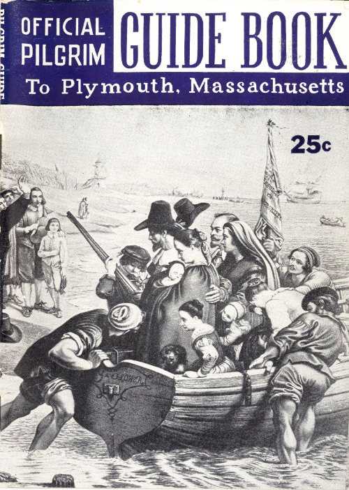
Cover design by Leo Schrieber, Plymouth, Mass. Cover photo from oil painting in Pilgrim Hall depicting Departure of Pilgrims from Delfthaven. Illustration, inside front cover, scene of two modern Pilgrim Misses from annual Thanksgiving Pageant held in Plymouth Memorial Building on Thanksgiving Day.
Published by
THE MEMORIAL PRESS
Plymouth, Mass.
This publication is one in the Pilgrim Book Series.
CONTENTS
- Page
- Brewster Garden 33
- Brewster Spring 34
- Burial Hill 16
- Old Fort 18
- Grave of William Bradford 21
- Site of Watch Tower 17
- Old Graves 19
- Cole’s Hill 40
- Court House 6
- Edward Winslow House 44
- Harlow House 61
- Howland House 59
- Industries 6
- Kendall Holmes House 62
- Leyden Street 32
- Massasoit Statue 43
- Mayflower Passengers 65
- Major John Bradford House 7
- Memorial Fountain 40
- Memorial Seat 42
- Morton Park 57
- National Monument to Forefathers 9
- Old Colony Club 5
- Pilgrim Hall 49
- Pilgrim Maiden 34
- Pilgrim Society 55
- Plimoth Plantation 13
- Plymouth Rock 37
- Plymouth Memorial Building 6
- Postoffice 6
- Registry of Deeds 47
- Sarcophagus 41
- Sandwich Street 60
- Sparrow House 57
- Standish Guards 6
- Summer Street 57
- Tabitha Plasket House 48
- Training Green 60
- The Compact 70
- Town Square and Churches 29
- Town Brook 32
- Watson’s Hill 56
CARVER AND NORTH STREETS, LOOKING TOWARD SHIRLEY SQUARE—North Street was laid out before 1633, and has been variously called, in old deeds, New Street, Queen Street, North Street, and Howland Street. Carver Street, once part of North, runs around Cole’s Hill, and connects with Leyden, oldest Plymouth street.
PLYMOUTH—THE TOWN
The Town of Plymouth, made famous as the permanent settlement of the Pilgrims, is the county seat of Plymouth County in southeastern Massachusetts. It is 37 miles southeast of Boston and is reached by rail, and by Routes north via the Old Colony Division of the N. Y., N. H. & H. R. R., and by automobile over routes No. 3 and No. 3A. It overlooks Cape Cod Bay and a well protected harbor. Its year ’round population is approximately 14,000. It has an area of 108 square miles, the largest in the State.
In addition to its historical association and its old records, among which one may browse at pleasure, the town has a fine public school system, public library, many churches, an excellent water system, several banks and theatres, an adequate fire and police department, a modernized hospital and high quality of public service. There are fine bathing beaches and recreational centers, hotels and accommodation for tourists.
Fraternal organizations are numerous. The Old Colony Club, organized 1769, the oldest social organization in America, is located on Court Street, opposite the Court House. Other active societies are the Plymouth Woman’s Club, the Plymouth Antiquarian Society, the Cordage Men’s Club, the Plymouth Country Club, the Girls’ Club, the Boys’ Club, the New Century Club, and the Manomet Village Club.
The Plymouth County Court House occupies a commanding position facing Court Street with the Registry of Deeds near at hand on North Russell Street and easily accessible to visitors. A new Federal Post Office Building stands at the historic corner of Leyden and Main Streets. A commodious armory on Court Street accommodates the National Guard. At one time this building was the headquarters of the Standish Guards, the local militia company organized and chartered in 1818.
Opposite the armory is Plymouth’s Memorial Building, dedicated in 1926 to the men of Plymouth who served in all the wars in which the country has been engaged. It has a large hall with a seating capacity of 2000 and was built at a cost of $300,000. This building is a few steps north of Pilgrim Hall, that sacred depository of Pilgrimiana, a mecca for modern day Pilgrims, visited every year by thousands from the world over.
The town has diversified industries. Its mills and factories are devoted principally to the production of high grade woolens, cordage, tacks and rivets, and zinc products.
AN ISLAND IN ONE OF PLYMOUTH’S MANY PONDS
Over 300 ponds of sparkling clear water lie within the town’s boundaries, and these together with its woodlands offer almost unlimited facilities for hunting and fishing, while salt water fishing is equally available.
Yes, Plymouth has much to offer as a place for permanent residence and as a summer resort.
The door is open and the word is Welcome.
Approaching Plymouth from the north and passing through Kingston, it is both convenient and of interest to visit the Major John Bradford House. This house stands on a knoll on Landing Road overlooking Jones River and the marshes. It was built in 1674 by Major John Bradford, son of Major William Bradford, Deputy Governor and Grandson of Governor William Bradford.
Legend:
During the King Philip War this house was partially burned while Major Bradford was moving his family to a place of safety. Upon his return Indians were seen surrounding the house, one of whom the Major shot while he was in the act of warning his comrades of the approach of the whites. This Indian, while wounded, crawled behind a fallen tree and some years later told Major Bradford of the circumstances of his escape, showing at the same time the bullet wound in his side received at the time.
Another fact of interest is that this house gave shelter for something like twenty-five years to the now famous “History of Plimouth Plantation,” sometimes spoken of as the “Bradford History” written by Governor Bradford and preserved in the State House in Boston.
Entering Plymouth through Court Street and passing the plant of the Plymouth Cordage Company, one comes to another old house. This house is known as the William Crowe House. It is located on the east side of the highway and was probably built in 1664 as in that year William Crowe married Hannah, daughter of the first Josiah Winslow. A deed dated 1665 from Francis Billington to William Crowe refers to the estate “on which Mr. Crowe now lives.” This undoubtedly establishes the house as one of the very oldest of Plymouth’s old houses.
Mr. Crowe’s widow married John Sturtevant. Her daughter Hannah Sturtevant married Josiah Cotton, a grandson of Rev. John Cotton. In 1709 Mr. Cotton became the owner, and in 1723 built the two-story addition.
Proceeding south through Court Street and turning west at Allerton or Cushman Street brings one to the National Monument of the Forefathers.
... This monument, towering high in its massive splendor, occupies a commanding position overlooking the town and harbor, with Duxbury, Clark’s Island, the Saquish and the Gurnet in the background.
The central figure is Faith, which stands on the main pedestal, one foot resting on a replica of Plymouth Rock. In the left hand is a Bible, while the right hand points heavenward. The whole attitude is symbolic of faith in a divine power, as the smaller statues below are representative of the principles enunciated by the Pilgrims themselves.
The plan of the base is octagonal. There are four protruding wings, on each of which is a figure seated. One representing Morality holding the decalogue in the left hand and the scroll of Revelation in the right. On the one side is a Prophet and on the other the Evangelists.
On the next pedestal is the figure representing Law with Justice on one side and Mercy on the other, symbolizing justice tempered with mercy. Education has on the one hand the wisdom of maturity and on the other Youth following experience. The fourth figure represents Freedom, a consequence of which is peace, represented on the one hand, while on the other is represented the overthrow of tyranny.
The main pedestal has four polished faces, on two of which are inscribed the names of the Mayflower Pilgrims, while another bears the inscription “National Monument to the Forefathers. Erected by a grateful people in remembrance of their labors, sacrifices and sufferings for the cause of civil and religious liberty.” There is one panel left for future use.
INTERESTING FACTS ABOUT THE MONUMENT
- Largest granite statue in the world.
- Designed by Hammatt Billings.
- Built of Maine granite.
- Cost $150,000.
- Statue of Faith cost $31,300; was given by late Gov. Oliver Ames. Other contributors: United States Government, States of Massachusetts and Connecticut, together with 11,000 individuals of this and other countries.
- Corner stone laid August 1, 1859.
- Monument dedicated on August 1, 1889.
- Height from ground to top of head, 81 feet.
- Outstretched arm measures, from shoulder to elbow, 10 feet, 1½ inches; from elbow to tip of finger, 9 feet, 9 inches; total length of arm, 19 feet, 10½ inches.
- Circumference of head at forehead, 13 feet, 7 inches.
- Circumference of left arm below sleeve, 6 feet, 10 inches.
- Length of finger pointing upward, 2 feet, 1 inch.
- Circumference of finger, 1 foot, 8½ inches.
- Circumference of thumb, 1 foot, 8½ inches.
- Length of nose, 1 foot, 4 inches.
- 216 times life-size.
- Weight, 180 tons.
JOHN ALDEN HOUSE, 1653, DUXBURY
John Alden married Priscilla Mullins in 1622. They first lived in a log house below Burial Hill where their first three children were born. The family later moved to Duxbury where they built and occupied the present house. This house is open to visitors.
A CUTAWAY DRAWING of the original Mayflower by John Seamans of Weymouth, Mass., from plans drawn by William A. Baker, Hingham marine architect and authority on ancient ships.
- KEY TO DRAWING
- 1 Main Deck
- 2 Galley
- 3 Upper Deck
- 4 Main Hatch
- 5 Forecastle
- 6 Waist
- 7 Bosun’s Stores
- 8 Shallop
- 9 Sail Store
- 10 Crew’s Quarters
- 11 Main Hold
- 12 Cargo
- 13 General Stores
- 14 Water Barrels
- 15 Spirits
- 16 Store
- 17 Cabins
- 18 Radio Room—A radio for the crossing was required by law.
- 19 Chart House
- 20 Steering Position
- 21 Gun Port
- 22 Main Deck
- 23 Upper Deck
- 24 Quarter Deck
- 25 Poop Deck
- 26 Beak
- 27 Bowsprit
- 28 Foretop
- 29 Maintop
- 30 Mizzenmast
- 31 Mainmast
- 32 Foremast
PLIMOTH PLANTATION—MAYFLOWER II
On a 100-acre tract, formerly part of the beautiful Hornblower estate, a replica of the Pilgrim First Street (now Leyden Street) with its original nineteen thatched dwellings is being erected under the auspices of Plimoth Plantation, Inc. When complete the project will have cost an estimated million dollars.
Nearby, in a bend in the Eel River, is the permanent anchorage of the Mayflower II, an exact reproduction of the original Pilgrim ship, built and financed by popular subscription in England.
The idea of reproducing a full-size, 92-foot 180-ton Mayflower replica was conceived during the North African fighting in World War II by a Londoner, Warwick Charlton. His dream was to memorialize the common heritage of English-speaking peoples, and to express his country’s gratitude for American aid in times of great stress.
Mayflower II was constructed of English oak and Oregon pine at an ancient shipyard in Brixham, Devon, using plans drawn up, after five years of research, by William A. Baker, shipyard executive with Bethlehem Steel. More than a quarter million English people contributed shillings and pence to the Project Mayflower fund.
PLIMOTH PLANTATION IN SOUTH PLYMOUTH
This is how the replica of the original Pilgrim settlement will look when finished.
Mayflower II is shown at its permanent anchorage in lower left center.
- Museum
- Parking
- Fort
- Gardens
- Trading Post
- Indian Village
- Mayflower
- Grist Mill-Jenney
- Eel River Pond
- To the Ocean
The Pilgrim village is located on a park-like site sloping up from Eel River. When complete it will include a trading post, grist mill, Indian village, and a fort meeting house, as well as dwellings identical with those occupied by Governor Bradford, Elder Brewster, Myles Standish, John Alden, and the rest. The work is being supervised by Charles R. Strickland, Plimoth Plantation architect.
The Plantation homes are designed to have the vertical planked siding, thatched roofs, and sheepskin parchment windows of Tudor times. They are being furnished with trestle tables, benches, trundle beds, sea chests, and the like. Women in costume working at old looms will weave linsey-woolsey, and dye it with butternut hull and hemlock bark decoctions.
Mayflower II comes to its permanent berth in the Eel River after an Atlantic crossing, and exhibitions at New York and elsewhere, under the command of Alan Villiers, of grain-ship fame. The ship will symbolize the wellsprings of American democracy. It will vividly recall the ideas forever shrined in the Compact, whereby the little company of dissenters bound themselves to live together by the law and under God.
All America will want to see how their nation was cradled, and so more keenly appreciate the noble tradition to which they are heir.
BURIAL HILL
CANNON OF THE PILGRIM ERA ON BURIAL HILL
Leaving the Monument and passing south through Allerton Street, crossing Samoset Street, and continuing straight over the hill to the Cornish and Burton Schools, we arrive at the northwest entrance to the old burial ground. Rising 165 feet above sea level this hill commands a fine view of the harbor and bay from Kingston and Duxbury on the north to the Pine Hills on the south. At the base of the hill is Town Square where in the immediate foreground rise the spires of the First Church (Unitarian) and the Church of the Pilgrimage, with Leyden Street leading to the harbor beyond.
Site of the
Watch Tower
On Burial Hill
Burial Hill, once called “Fort Hill,” is one of the most historic and beautiful spots in Pilgrim Plymouth. There are convenient seats under the shady trees where one can rest and look out over Plymouth Harbor and Cape Cod Bay. Here on the “Hill” are the graves of the early colonists, the site of the Watch Tower, the Replica of the Powder House, the site of the “Fort.” People come here from all over the world to search for the graves of their ancestors. The guide map, giving location of all the graves, which is included in the Pilgrim Book of Burial Hill and Its Epitaphs, is invaluable to those who wish to get the most out of their visit to Pilgrim Plymouth. In leaving Burial Hill by the Town Square entrance, note the view down Leyden Street, first street in New England, and remember that down this same path once walked the Pilgrims of Plymouth.
PLYMOUTH HARBOR AND CHURCH OF THE PILGRIMAGE
From Burial Hill, where the early graves are located and where the Fort and Watch Tower and Powder House were built by the Pilgrims
From this vantage, and before the day of steam trawlers, Plymouthians have viewed the fleet of white-winged mackerel vessels as they sailed to and fro within easy vision against a background of blue sea.
On clear days the sand dunes of Cape Cod as well as Provincetown may be seen.
It was on this hill that the Pilgrims built their fort in 1622 and a watch tower in 1643 and another and larger fort during the King Philip War in 1675 as a defence against Indian attack.
There is no record of its first use as a burial ground. There are six stones bearing dates of the 17th century, the oldest that of Edward Grey (1681). It is known that William Bradford died in 1657 and a monument erected in 1825 bears evidence to that fact. Also that John Howland died in 1672 and his present stone was erected (circa) 1850. It is presumable that there were many burials here prior to these dates, although the first burials were on Cole’s Hill just above the shore.
A TRIBUTE IN VERSE FROM PILGRIM PLYMOUTH
Oft’ have I stood on Plymouth’s sacred hill
That overlooks both harbor and the town;
Its first laid street, a Pilgrim mecca still,
Steeped in historic precept and renown.
Where bay in iridescence greets the eye,
Flecked by ocean breeze and white-winged sail.
While in the foreground looking toward the sky
Are silent emblems of a past travail.
Hallowed the ground whereon they humbly dwelt,
Where now in honor sleep our reverend sires;
Where once in life they oft’ devoutly knelt
And asked for guidance only faith inspires.
What wealth of legend, yea, what wealth of lore,
Abounds along this tranquil Pilgrim shore!
The oldest stones in order of dates on the hill are those of:
| Edward Grey | 1681 |
| William Crowe | 1683-4 |
| Hannah Clark | 1687 |
| Thomas Cushman | 1691 |
| Thomas Clark | 1697 |
| The children of John and Josiah Cotton | 1699 |
| The stone of Nathaniel Thomas | 1697 |
ONE OF MANY OLD STONES ON BURIAL HILL
There is a doubt concerning the last named as the inscription is now illegible, but his death is supposed to have occurred in 1697.
Near the northwest entrance through which we entered is the replica of the old Powder House built in 1770 and later demolished. The present structure was a gift of the Massachusetts Society of the Sons of the American Revolution.
Burial Hill was well chosen as the site of the first fort. As it was easily approachable from First Street (now Leyden) and commanded the surrounding territory for some distance in all directions, it served as an excellent defense against attack by Indians. The locations of the fort and watch tower are marked by appropriately inscribed tablets.
But a few steps away to the north is the grave of Gov. William Bradford (numbered 32) over which stands a marble shaft erected in 1825, bearing the Latin inscription, the free translation of which is: “What our Fathers with so much difficulty attained, do not basely relinquish.”
The inscription on the south side reads:
H. I. William Bradford of Austerfield, Yorkshire, England. Was the son of William and Alice Bradford. He was Governor of Plymouth Colony from 1621 to 1633, 1635 to 1637, 1639 to 1643, 1645 to 1657.
The inscription on the north side follows:
Under this stone rest the ashes of William Bradford, a zealous Puritan and sincere Christian Gov. of Ply. Col. from 1621 to 1657, (the year he died, aged 69) except 5 yrs. which he declined.
There is also a text in Hebrew, now almost obliterated, which has been translated,
“Let the right hand of the Lord awake.”
Descendants of Governor William Bradford are buried in the immediate vicinity.
No. 33—Major William Bradford, Dep. Gov. of Plymouth Colony, and a son of Gov. Bradford. The inscription on this stone is as follows:
Here lyes ye body of ye honorable Major William Bradford who expired Feb’ ye 20th. 1703-4 aged 79 years.
He lived long, but still was doing good,
And in his country’s service lost much blood,
And a life well spent, he’s now at rest,
His very name and memory is blest.
At the grave of Joseph Bradford, another son, the inscription on the stone reads as follows:
Here lyes ye body of Joseph Bradford, son of the late Honorable William Bradford, Esq., Governor of Plymouth Colony, who departed this life July the 10th, in the eighty-fifth year of his age.
No. 35—Stone over the grave of John Howland, the last of the Mayflower passengers who lived in Plymouth. The inscription on this stone reads as follows:
Here ended the Pilgrimage of John Howland, who died February 23, 1672-3 aged above 80 years. He married Elizabeth, daughter of John Tilley, who came with him in the Mayflower Dec. 1620. From them are descended a numerous posterity.
“He was a godly man and an ancient professor in the wayes of Christ. Hee was one of the first comers into this land and was the last man that was left of those that came over in the Shipp called the Mayflower that lived in Plymouth.” (Plymouth Records.)
No. 44—Stone at grave of William Crowe bearing dates 1683-84.
For complete story of Burial Hill and detailed guide map showing name and location of all the graves the reader is referred to The Pilgrim Guide to Burial Hill and Its Epitaphs, available at most Plymouth stores. The map is indispensable in locating the graves.
No. 40—Stone to Thomas Clark 1697.
Stone to Hannah Clark 1697.
Near the stone of Thomas Clark is stone to Nathaniel Clark, his son. The latter was a councilor to Sir Edward Andros, Governor of New England.
No. 38—Stone to John Cotton 1699.
Graves of the Cottons. Three sons of Rev. John Cotton and seven sons of Josiah Cotton.
The Cushman gravestone 1691. This noted gravestone is one of the six bearing date in the seventeenth century. This ancient landmark was removed by the descendants of Elder Thomas Cushman to make room as they say “for a more enduring memorial.”
The Cushman monument on the north side of the hill was erected in 1858 in memory of Robert Cushman, his wife Mary, and Thomas Cushman, the latter for many years a ruling elder in the First Church.
The foregoing are the oldest stones on the hill.
Others are: No. 31—Thomas Faunce 1646-1745. Elder First Church 1699-1745. Town Clerk 1685-1723.
No. 36 is the grave of Nathaniel Jackson. The stone is the oldest Masonic stone on the hill. It is dated 1743.
No. 37—Stone over the grave of Francis LeBaron 1704. The “Nameless Nobleman.”
No. 41—Grave of sailors from brig Gen. Arnold who perished in Plymouth Harbor. James Magee of Boston was the unfortunate commander of this ill-fated ship. The site is marked by a monument erected through the generosity of Stephen Gale of Portland, Maine. This is on the west side of the hill.
No. 42—Tabitha Plasket, June 10, 1807. (Epitaph on following page).
No. 43—Gen. James Warren lot. Patriot and Soldier.
No. 45—Site of fort built in 1622; the lower part was used for a church; also fort built in 1675—100 ft. square with palisades 10½ ft. high.
There are many peculiar epitaphs, some in prose and some in verse, and expressive of about every shade and degree of sentiment. A few of these follow:
(Blue stone, slate. Top and right-hand corner gone) Capt. Ellis Brews—— and Nancy —— wife died Dec. 13, 189— aged —4 years (where lines appear letters and figures are obliterated). The name, however, is Brewster, and originally read—Son of:
“He listen’d for a while to hear
Our mortal griefs then turned his ear
To angel harps and songs and cried
To join their notes celestial sigh’d and dyed.”
(Low blue slate. Sound and compact. Symbol). In memory of Frederic, son of Mr. Thomas Jackson and Mrs. Lucy, his wife who died March 15, 1788, aged 1 year and 5 days.
O! happy Probationer! accepted, without being exercised!—It was thy peculiar Privilege not to feel the slightest of these Evils, which oppress thy surviving kindred.
(Blue slate; pyramidal; good condition. At top bust of female under curtain drapery. The epitaph is from Young’s Night Thoughts, “Narcissa.”)
Fanny Crombie, daughter of Mr. Calvin Crombie and Mrs. Naomi, his wife. Departed this life June 25th, 1804, in the 8th year of her age.
As young as beautiful and soft as young
And gay as soft and innocent as gay.
Note: In quoting these epitaphs the writer has referred to book compiled in 1894 by the late Benjamin Drew of Plymouth.
(Blue slate. Good condition. Weeping willow and urn.)
To the memory of ISAAC COAL, son of Mr. Isaac Coal and Mrs. Sarah, his wife, who died Aug. 28, 1825, in the 17th year of his age.
Friends and Physicians could not save
His mortal body from the grave
Nor can the grave confine him here
When CHRIST shall call him to appear.
(Blue slate. Good condition. Weeping willow and urn).
In memory of Mrs. Tabitha Plasket, who died June 10, 1807, aged 64 years.
Adieu vain world I have seen enough of thee
And I am careless what thou say’st of me
Thy smiles I wish not;
Nor the frowns I fear
I am now at rest my head lies quiet here.
(Stone of blue slate. Moss grown. Defaced. Cleft Broken Symbol.)
—ere lyes Buried—body of Mrs. Sarah Atwood, wife of Deacon John —— died Jan. ye 22d 1725 in ye 37th year of her age.
(Purplish blue slate. Nearly covered with moss. Symbol surrounded with blossoms.)
The memory of the Just is Blessed.
Here lyes the Body of Mr. John Atwood who died on the 6th of August A D 1754 AEtatis 70 years. He was a Man of Piety & Religion Adorned with every Christian grace & virtue & therefore well qualified for ye office of a Deacon which he discharged in ye first Church of Christ in this Town for about 40 Years with Honesty & uprightness and in the Course of his Life adorned the Doctrine of His Saviour by a well ordered Conversation.
Some are truly inspirational as shown by the following:
(White marble, fair condition, Urn.)
Patience C. Holmes, Daug. of Nathan and Ruth Holmes. Died April 1, 1845, in her 24 y’r.
“Shed not for her the bitter tear
Nor give the heart to vain regret,
’Tis but the casket that lies here;
The gem that fill’d it sparkles yet.”
Monument
In memory of Seventy two seamen who perished in Plymouth harbour on the 26 and 27 days of December 1778, on board the private armed Brig, Gen. Arnold, of twenty guns, James Magee of Boston, Commander, sixty of whom were buried on this spot.
(On the northwesterly side.)
Capt. James Magee died in Roxbury, February 4, 1801; aged 51 years.
Note: This monument was erected by Stephen Gale of Portland, Maine, a stranger to them, as a memorial to their sufferings and death.
One of the most recent burials here was that of Judge Thomas Russell who was buried here at his special request.
Judge Russell was a native of Plymouth, the son of Thomas and Mary Ann (Goodwin) Russell. He was a noted jurist, was appointed by President Grant United States Minister to Venezuela and was President of the Pilgrim Society on the occasion of General Grant’s visit to Plymouth. His stone of native granite bears the inscription: Thomas Russell, born Sept. 26, 1825, Died Feb. 9, 1887.
The brass cannons shown above are on the east side of Burial Hill near the site of the old fort. They were presented to the Town of Plymouth by the British Government as an expression of Good Will during the Tercentenary period and were transmitted through the Ancient and Honourable Artillery Company of London to the Ancient and Honorable Artillery Company of Massachusetts. On the right is a “Minion.” On the left a “Sakeret,” both of the mid-16th century era. They were formerly in the collection of the British National Artillery Museum and are similar to the cannons mounted on the first fort to protect the colony from attack of Indians.
PILGRIMS PROGRESS, presented each Friday in August by the Plymouth Antiquarian Society. This is a colorful event, impressive and inspirational in its simplicity.
TOWN SQUARE AND CHURCHES
Leaving the hill at the southeast slope and following down the terraced brick and granite walk, we step into Town Square. This is the logical center of the town and it may well be said, for generations the seat of government with the Town House on the south side, bearing its descriptive tablet. Just ahead is the first street leading to the water and reaching to the north is Main Street.
Let us here face about. As we look up the square we face the First Church (Unitarian), so called by virtue of its succession of unbroken records, the oldest volume of which may be seen in Pilgrim Hall. This church was dedicated on Dec. 21, 1899. Its arched portal is an elaborate copy of the portal of the church at Austerfield, England, in which Gov. Bradford was christened. A tablet near the entrance bears the following inscription:
The Church of Scrooby, Leyden, and the Mayflower gathered on this hillside in 1620, has ever since preserved unbroken records and maintained a continuous ministry, its first covenant being still the basis of its fellowship. In reverent memory of its Pilgrim founders this fifth meeting house was erected A. D. MDCCCXCVII.
At the east end of the church is a memorial window representing John Robinson delivering his farewell address to the Pilgrims. This window is an artistic masterpiece. It was designed by Edward P. Sperry and since its installation it has been an object of much interest to visitors to Plymouth. Numerous other windows are commemorative of historic events.
The wood church of Gothic design occupying this site previous to erection of the present edifice, was built in 1830 and was destroyed by fire on Nov. 22, 1892.
On the right of the square is the Congregational Church, or Church of the Pilgrimage, erected in 1840, on which is a tablet with the following inscription:
This tablet is inscribed in grateful memory of the Pilgrims and of their successors who, at the time of the Unitarian controversy in 1801, adhered to the belief of the Fathers, and on the basis of the original creed and covenant perpetuated, at great sacrifice, in the Church of the Pilgrimage, the evangelical faith and fellowship of the Church of Scrooby, Leyden, and the “Mayflower” organized in England in 1606.
The first meeting house was erected in 1637 near the Gov. Bradford House. This building contained a bell, as did the more pretentious building erected in 1683 with its diamond leaded windows, Gothic roof, etc. In 1744 still another place of worship was erected nearer the site of the present First Church, and this remained until 1830, when the church that preceded the present church was built.