The young trees growing in the Devastated Area have not been planted by man, but are natural reforestation. In National Parks nature takes its course. Man’s meddling, even though well intentioned, often upsets the balance of nature, with resultant undesirable and unforeseen effects.
In summertime christine lupine (cream-colored) is abundant here. In the fall, rabbitbrush (yellow) is conspicuous.
RABBITBRUSH (yellow)
CHRISTINE LUPINE (pale yellow)
In late summer and fall, deer are numerous on the lower slopes of Lassen Peak. Some of the deer seen here are mule deer and its more common sub-species called the black-tailed deer, both recognized by their tails. The sub-species has a tail entirely black, and the mule deer has only the lower tip black with the remainder the color of its coat.
(0.7 mile)
MULE DEER MIGRATE TO THE EAST
BLACK TAILED DEER MIGRATE TO THE WEST
45 RAKER PEAK to the north is a 1,200-foot cone of andesite lava through which a stiff dome of dacite later welled up, the latter forming the cliffs. Logs felled by Lassen’s hot blast of May 22, 1915, are also visible on its lower slope. The mountain was named Raker Peak in 1933 to perpetuate the memory of John E. Raker, Representative from California and author of the successful bill making Lassen a National Park in 1916.
Across the road to the west, on the left base of the slope, is a small patch of mature trees. The mound, called “SURVIVORS HILL,” protected these trees from both the mudflow and the great Hot Blast. Survivors Hill also protected a patch of forest on Raker Peak where a patch of old trees still stands unscathed, surrounded by down timber.
(0.4 mile)
46 OLD BOUNDARY SPRING lies in the grove of white-trunked quaking aspen trees just southwest and below the level of the Road. The spring provides excellent drinking water. Through this site once passed the original park boundary, hence the name.
Quaking aspens are sun-tolerant trees, members of the poplar family. In autumn, their leaves turn a golden-yellow, sometimes tinged with red. It is a short-lived tree and is often a pioneer in areas denuded by fire or other means. It provides shelter and water-retention, assisting in the establishment of young coniferous trees which eventually crowd out the aspens.
(0.5 mile)
47 An EMERGENCY TELEPHONE is on the east side of the Park Road.
(0.4 mile)
48 HOT ROCK is one of the many large boulders carried from the top of Lassen Peak. In the mudflow of May 19, 1915, these boulders were known to the local people as “hot rocks” because they retained their heat for several days. These which were buried in the mudflow material formed enough steam to cause funnel-shaped “eruption pits” in the mud overlying them. These pits can still be seen by careful searching in the upper portion of the Devastated Area.
The Lassen Park Road is closed in winter beyond the skiing area at No. 3 in the Road Guide.
—NPS photo by R. C. Milne
When the road is finally opened in early June, visitors drive through 20 ft.
deep canyons of snow.
—NPS photo by R. C. Milne
Brokeoff Mountain, described at No. 7 in the Road Guide, is part of the
remnants of ancient Mt. Tehama.
—NPS photo by R. C. Milne
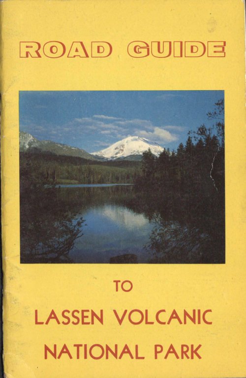
A good place to photograph Lassen Peak at sunset is at Reflection Lake,
No. 65 in the Road Guide.
—NPS photo by R. C. Milne
The numerous log and boulder jams were built up behind obstacles as the mudflow began to lose its tremendous size and momentum. The new forest growth is partly obscuring this feature, and before long all traces of the devastation will be obscured.
(0.4 mile)
49 LOST CREEK CROSSING. This stream has cut a trench not only through Lassen’s recent mudflow, but through earlier ones, some of which were separated by rather long periods of time. Upstream can be seen two lower layers of tree stumps, still erect and in place, laid bare by the erosive action of Lost Creek.
This is also a good place to observe the activities of the water ouzels.
The Nobles Trail parallels the road a short distance to the east. It was in use until completion of the main road through the park in 1934.
(0.1 mile)
50 WEST BOUNDARY OF THE DEVASTATED AREA. The Great Hot Blast did not affect this area and only the effect of the mudflow of May 19, 1915, is visible. Recent growth of vegetation is healing the scars, but a change in soil, distribution of battered-down logs, barked tree trunks, and the change in the profile of the stream-cut bank across Lost Creek can still be seen.
(0.6 mile)
51 The LOST CREEK DIVERSION DITCH is below on the outside edge of the road. It was dug by Italian labor crews for the Shasta Power Company as a part of a water collection system for Battle Creek electrical development before this region became a National Park.
(0.1 mile)
52 On the inside bank of this turn, above the road, is a cross section of the LOST CREEK DIVERSION DITCH. The eruption of Lassen Peak on May 19, 1915, ended a long controversy between the power companies and the pioneer settlers regarding water rights by destroying, shortly after completion, the whole intake section at a point not far from here, upstream.
(0.9 mile)
53 In this area and on the slope above is an intermediate step in NATURAL REFORESTATION after a fire. The luxuriant growth of young white fir and jeffrey pine has been possible through soil stabilization and moisture retention accomplished by shrubs.
(0.5 mile)
54 A fine specimen of SUGAR PINE.
(0.3 mile)
55 LOST CREEK ORGANIZATIONAL CAMP is used only by organized groups. Reservations for this and other free group campgrounds in the park must be made in advance by writing to the Superintendent, Lassen Volcanic National Park, Mineral, Calif., 96063. Camping space in the other campgrounds is available on a first come first served basis.
(0.2 mile)
56 A magnificent PONDEROSA PINE.
(0.2 mile)
57 This stretch of forest, especially on the east side of the road, may be called a “MICRO-CLIMATE.” The southwest exposure, in a sheltered depression, produces a warmer climate which supports white fir, incense cedar, ponderosa pine, sugar pine, shrubs and annuals characteristic of lower elevations. The green carpet covering the low rocks and parts of the forest floor is called squawcarpet ceanothus.
(0.3 mile)
SUGAR PINE (cone 12 inches)
INCENSE CEDAR (cone 1 inch)
PONDEROSA PINE (cone 3 inches)
58 On the eastern extension of the sharp curve is a loose ROCKY TALUS SLOPE composed of fine-grained, dark grey boulders known as basalt. Often basaltic lavas are very porous because they are typically gas-rich when molten, and many bubble holes result as the escaping gases are trapped during cooling. This lava is relatively low in silica and high in iron, hence it is dark in color and heavy in weight.
(0.6 mile)
59 PROSPECT PEAKS are Hawaiian or shield volcanos made of countless thin basaltic lava flows from a central vent, producing shield-shaped outlines. The sharp peaks on top of these two mountains are small cinder cones. Badger Mountain is a plug volcano like Chaos Crags or Lassen Peak. West Peak is outside the park and on it is a Forest Service fire look-out station. To the north and northeast are typical virgin forests mantling a sea of minor volcanic peaks.
Landscape
- LATOUR BUTTE
- MAGEE PEAK
- SUGAR LOAF PEAK
- HAT CREEK RIM
- HAT CREEK FAULT
- WEST PROSPECT PEAK
- PROSPECT PEAK
- BADGER MT.
The HAT CREEK FAULT SCARP, outside the park, is a great crack in the earth where an enormous block to the east, known as the Hat Creek Rim, rose. The scarp, or bluff, runs about 25 miles north. This is the beginning of the so-called basin range structure of Nevada which is largely composed of such variously tilted fault blocks.
(0.6 mile)
60 NOBLES PASS, elevation about 6,000 feet, was discovered by William H. Nobles. In 1852 he offered to reveal the route to business men of Shasta City, then the leading settlement of Northern California, for $2,000. The new route, the most popular into this region, started at Black Rock, Nevada, and entered the northeast corner of the park at Butte Lake. This Nobles, or Old Emigrant, Trail is still visible to the northeast through the chaparral. From this point, it went west along the south base of Table Mountain and left the park near the highway “Y” beyond Manzanita Lake. Numerous authentic pioneer relics have been found along the route.
The chaparral brush formation here is composed of greenleaf manzanita, snowbrush, ceanothus, and bitter cherry. Establishment of the chaparral is often the first step in the natural reforestation of an area swept by forest fires.
(0.4 mile)
61 This is one of the largest WHITE FIR trees in the United States. It is 168 feet high and has a circumference of 20 feet, 7 inches.
WHITE FIR
This vicinity is known as SUNFLOWER FLAT due to the abundance of the flower-like plant called wooly wyethia which blossoms in mid-summer. Other flowers to be seen are: skyrocket gilia, California stickweed, Nuttall larkspur, and Pacific monardella. A few brilliant red snowplants are often to be found here up into mid-summer. Remember, no flower picking is allowed in our National Parks.
SKYROCKET GILIA (red)
CALIFORNIA STICKSEED (white)
NUTTALL LARKSPUR (blue)
PACIFIC MONARDELLA (white to lavender)
(0.2 mile)
62 The sudden change in topography indicates the east edge of CHAOS JUMBLES ... the huge landslide from nearby Chaos Crags.
This upper edge of the hummocky rock debris is thin, and lies on a relatively flat undersurface. As a result, the forest trees grow normally here, in contrast to the dwarf forest to be found on the main mass of thick, sloping, and very porous Jumbles.
The pale yellow-green, moss-like material on the tree trunks is called staghorn lichen. It is not a moss, but is a union of two plants growing together; a fungus, giving it form and body, and an alga, growing inside and manufacturing food for both from the air and sunshine. Lichens do not in any way harm the trees, and grow as well on dead material.
(0.6 mile)
63 The pink mountain mass to the south is CHAOS CRAGS. It is composed of three plug volcanos of a lava known as dacite. This material was rapidly pushed up in a molten state, much as one would squeeze paste from a tube. As the lava plugs cooled and hardened, steam explosions took place from the base of the cliff, undermining it and causing at least three tremendous avalanches estimated as occurring about 1700 years ago, 700 years ago and the most recent in about the year 1690. Due to the small amount of soil and porous rock, many of the stunted trees in this Dwarf Forest are over 200 years old.
(1.1 mile)
Landscape
64 VISITOR CENTER, LODGE and CAMPGROUND, elevation 5,950 feet, is the center of visitor facilities and services.
The Visitor Center is open daily. Free naturalist-conducted hikes, caravans, and nature walks originate here. Informal campfire programs are presented nightly in the Manzanita Lake Campground Amphitheater from June through mid-September.
The LILY POND SELF-GUIDING NATURE TRAIL, an easy 1-mile loop route, starts just across the road from the Visitor Center. It is unique in having ten species of cone-bearing trees and three species of broad-leaved trees along its short and nearly level route.
GOLDEN-MANTLED GROUND SQUIRREL · CHIPMUNK
Abundant wildlife, including deer and a large variety of birds, is found in the Manzanita-Reflection Lakes area. The most common rodents are the golden-mantled ground squirrel and the chipmunk.
The Loomis Museum, with a tract of 40 acres, was given to the Federal Government in 1927 by Mr. and Mrs. Benjamin F. Loomis in memory of their daughter, Mae. On this land are now located the public lodge and dining room, curio store, service station, grocery store and postoffice.
The National Park Service emblem pictured here was adopted in 1953. Many visitors confuse the Park Service (Department of the Interior) with the Forest Service (Department of Agriculture). Briefly, the National Park Service preserves the National Parks and Monuments in an unchanged state, while the U. S. Forest Service operates National Forests on a sustaining yield basis.
(0.1 mile)
JEFFREY PINE (cone about 5 inches)
SNOWPLANT (red)
COW LILY (yellow)
65 REFLECTION LAKE, elevation 5,880 feet. A few hundred feet ahead is the road to the Reflection Lake Picnic Ground. There tables, fireplaces, and rest rooms are available for free visitor use.
Reflection Lake gets its name from the fine reflections of Lassen Peak and Chaos Crags to be seen in it from near the picnic ground. It is an excellent place for photography, especially in the afternoon or early evening.
On summer evenings nighthawks can be seen cruising over the lake, emitting their unique harsh cries and their startling “whoomm” sound in flight. Bats on the wing also are seen in the evenings feeding on insects.
(0.2 mile)
BROWN BAT
NIGHTHAWK
66 On the down hill side of the road is MANZANITA LAKE, elevation 5,845 feet. This lake is young, formed by the Chaos Jumbles landslide. The water level was raised a few feet in 1912 by the Northern California Power Company, for electric power development purposes by the construction of a small earth dam at the lake’s southwest extremity.
Like most of Lassen’s lakes, it is well stocked with trout. In the fall large numbers of waterfowl, including Canada geese, stop here en route to their wintering grounds.
The lake derived its name from the abundance of greenleaf manzanita on its shores. This shrub can be seen across the lake to the south.
(0.2 mile)
67 MANZANITA LAKE ENTRANCE STATION. Vehicle entry permits and information may be procured daily during the summer season.
Lovely views of Lassen Peak are to be had along the Lake Trail just a few feet from the Entrance Station at this end of the lake. It is a fine area for taking photographs, especially in the afternoon and early evening. Lassen Peak towers 4,625 feet above Manzanita Lake to an elevation of 10,457 feet. The summit notch in the 1917 crater, and the black tongue extending down toward the right is the youngest rock in contiguous United States, pouring out as molten, redhot dacite lava on the night of May 19, 1915.
Landscape
- 1915 DACITE (SW LAVA FLOW)
- 1917 CRATER STEAM
- EAGLE PEAK
- SKI HEIL PEAK
- CHAOS CRAGS
- LASSEN PEAK
- LOOMIS PEAK
- MANZANITA LAKE
AUTO TRIPS TO OTHER POINTS OF INTEREST
1. BIG SPRING, SUBWAY CAVE (lava tube), and BURNEY FALLS STATE PARK, 8, 14, and 41 miles respectively north of Manzanita Lake on Highway No. 89.
2. BUTTE LAKE CAMPGROUND and 1½-mile hike over the Old Emigrant Trail to CINDER CONE (Self-Guiding Nature Trail). A 30-mile drive from Manzanita Lake; proceed north on Highway No. 44 for nearly 15 miles, east, and later south, following the signs 15 miles to Butte Lake.
3. WARNER VALLEY and DRAKESBAD: South and east on Highways No. 89 and No. 36 to Chester, then north and west on an oiled road 18 miles to Drakesbad. (Self-guiding Nature Trail).
4. JUNIPER and HORSESHOE LAKES: via dirt roads about 18 miles north from Chester.
The Loomis Museum Association is a non-profit organization which is dedicated to the accumulation and dissemination of information concerning the human and natural history of Lassen Volcanic National Park. The following publications are available at the Manzanita Lake Visitor Center during the summer and at Park Headquarters in Mineral all year. Mail orders should be addressed to Loomis Museum Association, Mineral, Calif. 96063. Price lists are available on request.
- LASSEN—HIS LIFE AND LEGACY—
- GEOLOGY OF LASSEN’S LANDSCAPE—
- PICTORIAL HISTORY OF THE LASSEN VOLCANO—
- ROAD GUIDE TO LASSEN VOLCANIC NATIONAL PARK—
- INDIANS OF LASSEN VOLCANIC NATIONAL PARK AND VICINITY—
- BIRDS OF LASSEN VOLCANIC NATIONAL PARK—
- FLOWERS OF LASSEN—
- FIELD GUIDE TO THE TREES AND SHRUBS OF LASSEN VOLCANIC NATIONAL PARK—
- AMPHIBIANS AND REPTILES OF LASSEN VOLCANIC NATIONAL PARK—
ASK
THE MAN IN THE
NATIONAL PARK SERVICE UNIFORM
He’ll be glad to help you!
BE PROUD OF THIS PARK
As a citizen of the United States it belongs to you.
Keep it unspoiled for your next visit and for future generations by helping to:
Prevent forest fires.
Protect the flowers, the animal life,
and the rock and mineral formations.
Keep it clean.
Transcriber’s Note
- A few obvious typographical errors were corrected.