On the dread Day of Atonement269 the high-priest was supported to the Holy House by two priests, while a third laid hold of one of the jewels on his shoulder. The sound of the golden bells was heard as he went alone within the inner veil, but priests and people waited in awe-stricken silence, till he came out to bless them by the very name of Iahu, and to send forth the goat bearing the sins of the nation to the grim precipice of Ṣûḳ—a mountain visible from Olivet—which rises over the Desert of Judah. Yet more rarely—perhaps only seven times in the period between Ezra and Herod—he left the Temple by the Shushan Gate, and passing over a high wooden causeway, ascended Olivet to burn the red heifer. Its ashes were mingled with water from Siloam, brought to the Temple, it is said, by innocent boys mounted on oxen, with much fear lest these should tread on some “grave of the depth,” or hidden tomb, and so defile the children who rode them, and who had been born in the outer court of the sanctuary. Without these ashes there was no purification for Israel from defilement by the dead. They were stored partly on Olivet and partly in the Temple.
The Feast of Booths was a time of rejoicing rather than of fear. It was then that the king, once a year, read the law to the people from a pulpit in the Court of the Women, and it is said that Agrippa I. wept at the words “Thou mayest not set a stranger over thee which is not of thy brethren,” touching the hearts of the people, who shouted, “Thou art our brother—thou art our brother.”270 For did he not yearly bear the basket of first fruits, when the bull with gilded horns was brought to the Temple, and “the pipe played before them till they came to the mountain of the house”? At “Tabernacles” also the pipes played at the feast of the “water-drawing,” when four golden lamps lighted up the Court of the Women, and Levites stood on the fifteen steps of Nicanor chanting the fifteen “songs of degrees,” while “pious and prudent men danced with torches in their hands, singing psalms and hymns before the people.” Two priests blew the rams’ horns in the court, and when they reached the Nicanor Gate they sang:
The paganism of Rome penetrated, however, even into the temple of Jehovah. The golden eagle—emblem of the empire—“erected over the great gate of the Temple,” was not cut down till rumour arose that Herod was dying.272 It perhaps spread its wings on the soffit of the lintel, as at Ba’albek and Si’a. The money-changers who—for a small charge—changed old half-shekels for the new ones, which alone could be given for the Temple tax,273 and the sellers of doves, were established in “shops” in the outer cloisters, and made the Holy House a “den of thieves.” The great fortress, built to defend the Temple on the north, and to guard the sacred robes of the high-priest, was held under Idumæans and Romans by a foreign garrison overawing the people. This fortress of Antonia requires a special description.
The former citadel, Baris, was rebuilt by Herod, and renamed Antonia after Mark Antony. The ridge rose naturally about 30 feet higher than the level of the Priests’ Court, stretching on the north to the hill of Bezetha, or the new north-east quarter of the city, not as yet walled in. The citadel was divided off from this hill by a trench with vertical scarps cut in the rock: it was 60 feet deep and 165 feet wide. A great block of rock was left standing within this fosse; it measures 140 feet north and south, and 352 feet east and west, thus covering more than a third of the width of the outer Temple court, and rising at its highest 30 feet above the Priests’ Court. The block was scarped on all sides, and thus a flat rock surface exists south of it, extending on the level of the court as far as the north wall and cloister of the outer Temple. Steps led up—as they still do—from this flat courtyard to the block above it.
This castle is very clearly described by Josephus.274 He applies to it the terms “Acropolis,” “stronghold” (phrourion), and “fortress” (purgos); but he never calls it Akra. There were four towers on the rocky block, one at each corner, that to the south-east being the highest. The flat space below on the south was paved, and in it were rooms, courts, bathing-places, and “broad spaces for parades.” Passages led below the Temple court—as already described in speaking of the Gate Ṭadi—but this area was on the level of the inner Temple court, as we learn from the exploit of the rash centurion Julian, during the siege by Titus; for, leaping down from the scarp, he charged the defenders of the Temple up to the gates, where his nailed shoes slipped on the Temple pavement, and he fell with a great clang of armour. Thus, the whole area of Antonia formed an oblong quadrangle, projecting on the north, and adjoining the north and west cloisters of the outer Temple enclosure. It was a citadel overlooking the whole of the sanctuary, and to the present day it is a barrack for Turkish troops.
The other Herodian citadel, which is also still a barrack, was at the north-west side of the upper city, by the upper market.275 It defended the neck of land where the upper city was always attacked from the north, and it adjoined Herod’s palace. The three “royal towers” here strengthened the old wall.276 Hippicus was farthest west and was only 25 cubits square. The present north-west tower of the citadel may be built on its site. Phasaelus was 40 cubits square, according to Josephus, with a solid base and a stoa round the tower itself. There can be little doubt that this refers to the present “Tower of David,” called the “Castle of the Pisans” in the Middle Ages. Its masonry is still untouched, being Herodian in style, with stones about 4 feet high and often 8 or 9 feet long.277 It measures 56 feet (about 41 cubits) north and south, but is 70 feet long east and west. It has a narrow walk or “berm” outside, on the solid base. A sloping revetment was added later by the Crusaders, and the upper part of the tower is modern. The site of the third tower, Mariamne, is as yet unknown, but its solid base, 20 cubits high, may exist under the pavement of the present market-place. It was the smallest of the three, being 20 cubits square. The bases of these towers are probably of rock, now covered with masonry. The reason why the original masonry of Phasaelus remains standing is that Titus left these towers, and a bit of the west wall, standing to show the strength of the fortress he had taken, and to form a citadel for the legion he left at Jerusalem. The palace, adjoining the towers inwardly, appears to have been large and magnificent, but its extent is not described. It had walls which made it a citadel, large bed-chambers, and wooden roofs. It was adorned with cloisters and carvings, and had gardens full of trees, canals, cisterns, and fountains where the water ran from bronze statues, while the doves fluttered round its pools as they now flutter in the Ḥaram courts. The pagan character of its adornment must have been sorely repugnant to Israel in the holy city. Two of its chambers were named after Cæsar and Marcus Agrippa, the pagan patrons of Herod.278
Other palaces were built later in Jerusalem, and Agrippa II. rebuilt the palace of the Hasmonæans,279 which was in the north-east part of the upper city, near the great Tyropœon bridge and the Xystos. The latter Greek word signifies a covered gymnasium, and there is no reason to doubt that this building was the same as the gymnasium built by the high-priest Jason before 170 B. C., which is described as being “under the Acropolis” or upper city. It lay north of the bridge,280 but its remains, and those of the neighbouring council-house, have not been identified with certainty. There were gates in the west wall of the Temple above it; and as these seem clearly to be the two central gates on that side, it must have been south of the ancient causeway, and down in the Tyropœon Valley. An “ancient hall” discovered by Sir Charles Warren, which he considers to be “one of the oldest buildings in Jerusalem,” may have some connection with either the Xystos or the council-house. It lies partly under the street leading to the Gate of the Chain, and measured about 23 feet by 20 feet; its floor is about on the level of the Herodian street pavement; its roof is less ancient than its walls; at each corner inside there are rude pilaster capitals of semi-Ionic character. The outer masonry is drafted and resembles that of Herod’s age. Herod assembled wrestlers and other athletes at his games every five years, but it is doubtful if his “theatre” was the same as the gymnasium; a “hippodrome” which lay towards the south of the Temple may, however, have been connected with the Xystos. It has been sought farther south by Mr. Bliss, but no remains of such a building were there found.281
Some alterations seem to have occurred in the water-supply in consequence of the building of the west outer wall of Herod’s Temple, and these indicate that the wall is later than two rock-cut aqueducts which it cuts across. The southern one of these ran from the Pool of the Bath to Siloam, and has been traced in parts by Sir Charles Warren and Mr. Bliss. The second led from north-west to the Antonia fosse, where possibly the “Pool Strouthios”282 was made by Herod when he rebuilt Antonia. This aqueduct merely served to collect the rain-water north of the city, and carried it originally to a rock tank which is included within Herod’s west sanctuary wall. The supply being thus cut off, the water of the aqueduct would serve to fill the Antonia fosse, or the Pool Strouthios in that fosse—known later as the “Twin Pools”—supposing that these were cut as early as Herod’s time. The great tunnel of this aqueduct under the Antonia rock stops dead at the Temple wall, and the only use that could afterwards be made of it would be as a secret exit, through the window which I discovered in this wall just south of the Antonia scarp.
The description of Herod’s Jerusalem may be concluded by notice of the Tyropœon bridge. The spring of the arch from the west wall of the outer Temple is still visible. The voussoirs are dressed with the peculiar criss-cross dressing already described as distinguishing Herodian masonry. The position and the breadth of the bridge closely agree with the dimensions given by Josephus (in Greek feet) for the three walks of the “Royal Cloister,” which ran east and west inside the south wall of the Temple enclosure283: since the south wall is about 9 feet thick, and the side aisles of the cloister were 30 feet wide, the central one 45 feet wide, and the pillars about 6 feet in diameter. This bridge replaced the older one, which was broken down at the time of Pompey’s siege in 63 B. C. The older voussoirs are under the Herodian pavement. The fallen voussoirs of Herod’s bridge lie on that pavement. The bridge, as explored by Sir Charles Warren, consisted of two great arches (about 42-feet span), with a pier 12 feet thick rising from a rock foundation in the Tyropœon Valley. The roadway was 95 feet above the valley bed, or 75 feet above the pavement. This is now buried to a depth of no less than 40 feet. The cloister within was the finest of those surrounding the Temple, and its pillars were of the Corinthian order. All other cloisters of the outer Temple were double, but this was triple. Those of the inner Temple were single.
Such generally was Jerusalem as Herod built its Temple and palaces, shortly before the birth of our Lord. The Temple was probably begun in 22 B. C. and finished eight years later. The fifteenth of Herod is preferable to the eighteenth,284 because Herod’s meeting with Marcus Agrippa appears to have occurred after the completion of the Holy House, and Agrippa died at Rome in 12 B. C. But additions continued to be made to the Temple down to 64 A. D.285 Thus, as we read in the fourth Gospel, the building had been continued for “forty-and-six years” before the time when the Jews were speaking to our Lord.
FOOTNOTES TO CHAPTER VI
226 Lucan, “Pharsalia,” viii. 698–9, x. 380–1; “Psalms of Solomon,” ii. 30–3; see Drummond, “Jewish Messiah,” 1877, pp. 140–1.
227 “Ant.,” XIV. viii. 1.
228 Ibid., XIV. xi. 4.
229 “Ant.,” XIV. xiii. 3–10.
230 Ibid., XIV. xiv. 5, xv. 2, xvi. 1–4.
231 “Ant.,” XV. v. 2.
232 Ibid., XV. i. 1.
233 Ibid., XIV. xvi. 2. That is eighteen sabbatic cycles after 163 B. C., which was a sabbatic year.
234 Matt. ii. 1; Luke i. 5, iii. 1, 23. The date of the Crucifixion depends on whether the Ministry covered one or four years.
235 “Ant.,” XVII. vi. 4.
236 Eleazar, son of Jacob, died about 130 A. D., and is quoted in Middoth, i. 9; Rabbi Meier was about the same age (quoted Midd., ii. 2); Rabbi Eleazar, son of Zadok (Midd., iii. 8) died about 120 A. D. See Chiarini, “Talmud de Babylone,” 1831, pp. 105–7. Nothing is said above of the pretended description by Aristeas, as the work is well known to be a forgery.
237 “Wars,” V. iv. 1, translated from the Greek.
238 Ibid., iv. 2.
239 “Wars,” V. vi. 5, vii. 3. This postern may have been the Corner Gate; see back, chap. iv. p. 82. Distinguishing this from the Valley Gate, the city had twelve gates in all.
240 “Recovery of Jer.,” 1871, pp. 149, 299, 300; Bliss, “Excav. at Jer.,” 1898, p. 29, and plate iv.
241 “Ancient Jerusalem,” 1908, p. 297.
242 Ibid., p. 23. The remains of an old wall outside the Damascus Gate date only from the twelfth century, and will be noticed later.
243 One at south-west angle is 38 feet 9 inches; another at north-east angle 23 feet 8 inches long.
244 The drafts, and a border 3 inches wide on the block, are worked with a comb of eight teeth to the inch in two directions, making a criss-cross pattern. The remainder is finely finished with a point.
245 See Sir C. Warren’s plates accompanying the “Memoir” (Jerusalem vol.).
246 Text No. 1, K’a ḳ’aḳ’at, “carelessness of brand” (Lev. xix. 28). Text No. 2, Le-’aṭṭ ṣ’an le-u, “for covering, removal to it.” The other markings seem to be initials of words—e.g. K twice for K’a (“carelessness”); Ṣ twice for Ṣ’an (“removal”); and Ḥ twice incised, perhaps for ḥaṭa (“error”), or for ḥaba (“hide”). Altogether ten out of twenty-two letters of the alphabet occur in these texts.
247 “Murray’s Bible Dict,” 1908, s.v. “Temple,” p. 876.
248 “Wars,” VI. v. 4.
249 “Mem. West Pal. Survey,” Jerusalem vol., 1883, p. 223; “Recov. Jer.,” p. 219.
250 “Ant.,” XV. xi. 5, referring to the royal cloister.
251 “Ord. Survey Notes,” plate xvi. figs. 1, 2.
252 For plan, elevation, and details, see plates ii. and iii., de Vogüé, “Syrie Centrale.” For Greek texts, Waddington, “Inscrip. de la Syrie,” 1870, pp. 540, 541, Nos. 2364–2369. No. 2366 is specially valuable as having a bilingual in Aramaic on the base. This gives ’Abisheth (“dry region ”) as the local name—Greek Obeisa—and M’aîru (“God-fearing”) for the Greek Moairos, with Malikoth (“royal”) for Maleichathos. Waddington supposes that the temple may have been raised by Idumæans (“Ant.,” XVI. ix. 2, 3). We have already seen that a Malichus lived in the time of Herod.
253 “Mem. West Pal. Survey,” Jersualem vol., p. 423; Josephus, “Wars,” V. v. 2. He means that some of the warnings were in Latin, some in Greek. The expression in the inscription mêthena allogenê is the same practically as the médena allophulon (“no foreigner”) of Josephus.
254 “Ant.,” VIII. iii. 9; “Wars,” V. v. 1, 2; “Ant.,” XV. xi. 3; “Wars,” I. xxi. 1. Josephus exaggerates the height of the walls, unless he means the command above the Kidron Valley.
255 Mishnah, Middoth, ii. 1. Abarbanel on this passage says, “The mountain was indeed much larger than 500 cubits would contain either way, but the sanctity did not extend outside this.”
256 See my “Handbook to Bible,” p. 371. Tosephoth Yom Tob.
257 The exact measures are: south wall of Ḥaram, 922 feet outside; east wall, 1,530 to the Roman north-east corner; west wall to Antonia, 1,601 feet; north wall, 1,042 feet. The north-east and south-west angles are right angles; the south-east angle measures 92½°. The old scarp on north side of the platform is about 1,180 feet north of the south wall.
258 Mishnah, Middoth, ii. 3: “All steps were half a cubit high.”
259 Josephus, “Wars,” V. ii. 5, VI. i. 8, ii. 7, iv. 1. The south-east part of the platform of the Dome of the Rock is supported probably by vaults. The entrance to these, on the east, was visible in 1881, though built up.
260 Mishnah, Middoth, i. 6–9.
261 Ibid., i. 4. On north the gates Niṣúṣ (“projecting”), Ḳorban (“gift”), and Môḳed (“hearth”), enumerated from east to west; on the south Dalaḳ (“burning”), Ḳorban (“gift”), and Mim (“waters”). The chamber of the draw-well (gulah) was on south near the last (v. 4). See Tamid, i. 4.
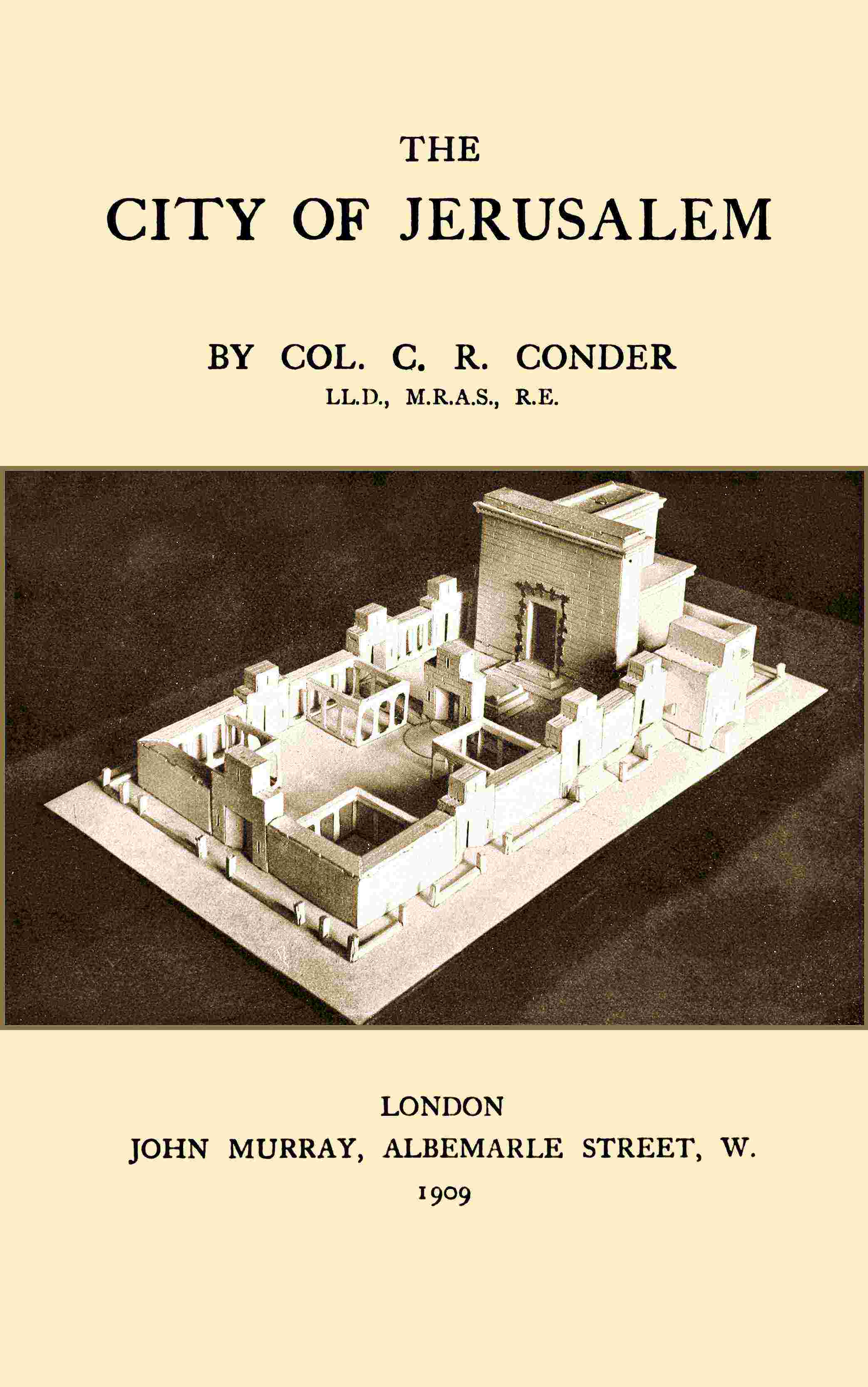
262 For plan and details, see Constantine l’Empereur, Codex Middoth, 1630; and Conder’s “Handbook to the Bible” (3rd edit. 1882), pp. 359–86. For model (Religious Tract Society), see Frontispiece.
263 Pal. Expl. Fund Quarterly, April 1903, p. 126, Oct. 1903, p. 326.
264 Acts iii. 2.
265 Middoth, i. 3; “Ant.,” XV. xi. 5. The Bible mentions the Parbharîm or “suburbs” (2 Kings xxiii. 11), close to the Temple. Standard records of the greater and lesser cubit were kept at the Gate Shushan (Mishnah, Tohoroth, xvii. 9).
266 “Ant.,” XV. xi. 7.
267 Sir C. Wilson, “Ord. Survey Notes,” 1864, p. 60; “Mem. West Pal. Survey,” Jerusalem vol., pp. 203–6, 270.
268 Mishnah, Middoth, i. 2; Yoma, i. 8, ii. 2; Tamid, i. 2-iii. 8, vii. 1.
269 Yoma, iv. 1, v. 2; Sukkah, v. 1–3; Parah, iii. 2–5, 11; Sotah, i. 5.
270 Mishnah, Sotah, vii. 8.
271 Ezek. viii. 16.
272 “Ant.,” XVII. vi. 2; “Wars,” I. xxxiii. 3.
273 Mishnah, Sheḳalîm, i. 3, 6, 7, iii. 2, vi. 4, 5.
274 “Ant.,” XV. viii. 5, xi. 3, 4, 7, XVIII. iv. 3; “Wars,” I. iii. 3, v. 4, xxi. 1, II. xvi. 5, V. iv. 2, v. 8, ix. 2, VI. i. 5, 8, ii. 5, 9.
275 “Ant.,” XIII. v. 11; “Wars,” V. iv. 1. The Rabbis (Tosiphta, Sanhed., chap. xiv.) mention an “upper” and a “lower” market.
276 “Ant.,” XVII. x. 2, 3; “Wars,” II. iii. 1, xvii. 6, 8, V. iv. 3, v. 8, VI. viii. 1, VII. i. 1; Tacitus, “Hist.,” v. 11.
277 Sir C. Wilson, “Ord. Survey Notes,” p. 46; “Mem. Survey West Pal.,” Jerusalem vol., pp. 267–70.
278 “Wars,” I. xxi. 1.
279 “Ant.,” XX. viii. 11; “Wars,” II. xvi. 3.
280 1 Macc. i. 14; 2 Macc. iv. 9, 12; “Wars,” II. xvi. 3, VI. iii. 2, vi. 2, viii. 1, V. iv. 2; “Mem. Survey West Pal.,” pp. 201, 202; “Wars,” VI. vi. 3.
281 “Ant.,” XV. viii. 1, 2, XVII. x. 2; “Wars,” II. iii. 1.
282 “Wars,” V. xi. 4; “Mem. Survey West Pal.,” Jerusalem vol., pp. 263, 264.
283 “Ant.,” XV. xi. 5. For the bridge see “Ant.,” XIV. iv. 2; “Wars,” I. vii. 2, VI. vi. 2, viii. 1. The bridge was 51 feet wide, and at 38 feet 9 inches from its south side was the outside of the south wall at south-west angle of the Ḥaram.
284 “Ant.,” XV. xi. 1; “Wars” I. xxi. 1.
285 “Ant.,” XX. ix. 7; John ii. 20. This date would be 24 or 27 A. D., reckoning from foundation.